When the eighth-century poet Wang Chih-huan (王之渙) wrote the famous lines, "If more distant views are what you desire, simply climb a storey higher (欲窮千里目, 更上一層樓)," he was not likely imagining that people 13 centuries later would follow the spirit of his words by launching satellites into space.
Wang's lines were used by President Chen Shui-bian (陳水扁) on Friday as part of the congratulatory address he delivered to the team responsible for the launch of the nation's second satellite, ROCSAT-2.
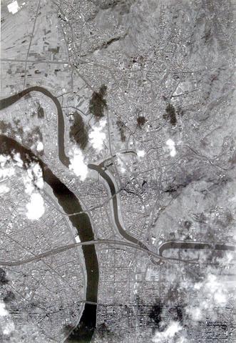
PHOTO: QUICK BIRD SATELLITE IMAGE, NATIONAL SPACE PROGRAM OFFICE
"In addition to broadening our ability to observe not only Taiwan but also the rest of the world, ROCSAT-2 increases our scientific knowledge," Chen said as he started, by remote link, ROCSAT-2's digital signal processor.
Chen was speaking at the Presidential Office, where a launch ceremony was being held simultaneously with a ceremony that was taking place at the National Space Program Office (NSPO) in Hsinchu.
Capable of producing images of objects as small as 2m across, and with its orbit set so that it can pass over Taiwan twice daily, ROCSAT-2 will provide timely and useful images of sites all over the nation.
"The satellite will provide useful applications for fields including utilities, agricultural and forestry planning, environmental monitoring, natural disaster evaluation and scientific research," NSPO Director Lee Luo-chuan (
The satellite is orbiting the planet 14 times a day and passes over the middle of the Taiwan Strait twice a day. The first daily pass-over of Taiwan, at 10:00am, allows eight minutes of imaging time. The second visit, at 10:00pm, is used to download to earth the data accumulated on board the craft.
Military purposes?
According to Lee, the satellite can provide imaging of the entire island of Taiwan by producing just four neighboring image strips -- assuming that the weather co-operates.
Also, through elevation-angle maneuvering, three-dimensional imaging data can be produced.
Lee said that the satellite can take photos of almost any spot on the globe and has great promise as a commercial supplier of satellite images.
"Marine pollution, coastal smuggling and other applications -- you name it," Lee said.
Although some have wondered whether the satellite could be used for military purposes, NSPO officials maintain that ROCSAT-2 was designed only for civilian purposes.
In the past, Taiwan has been one of the world's biggest buyers of satellite information. Each year the government and private research institutions spend large amounts of money on satellite data -- data covering topics from climate to topography.
"Because of ROCSAT-2, Taiwan can now become a satellite image exporter," Lee said.
According to the NSPO, two research institutes in Japan have asked about purchasing ROCSAT-2's images. Acquiring up-to-date satellite images of the areas near Japan -- including North Korea -- became an urgent need for Japan after two recent satellite projects failed, officials said.
Better clarity
NSC Deputy Minister Shieh Ching-jyh (
"Importantly, Taiwan can operate the satellite independently for various purposes," Shieh said.
Chen Shao-hsing (
Also expressing interest so far in purchasing images are world-class commercial satellite-image suppliers such as QuickBird, Space Imaging's IKONOS and SPOT.
Citing as examples high-resolution QuickBird images of Kaohsiung Harbor and Taipei City, Chen said the unit price for such images exceeds NT$360,000.
"In the future, ROCSAT-2 will produce similar but even more valuable images due to the better clarity we will be able to achieve," Chen said.
Meanwhile, the NSPO's Image Processing System (IPS), an integrated hardware and software system that handles remote-sensing image data, has generated interest among universities engaged in disaster prevention and geographic research.
Last August, NSPO demonstrated the capabilities of IPS, which can receive and generate remote-sensing image data from satellites. To date, 10 research units from various universities have placed orders for the machine, whose unit price is NT$5 million.
"Taiwanese businesses engaged in image-processing might also get a boost from the availability of clear satellite images from ROCSAT-2," Chen Shao-hsing said.
Wei Che-ho (
The satellite, costing NT$4.7 billion, was designed and built by the NSPO in collaboration with Astrium Co of France.
After the project got under way in 2000, Astrium chose six Taiwanese companies as sub-contractors: Acer Sertek, which manufactured ROCSAT-2's on-board management unit; Tatuing System Technology, which developed the craft's on-board flight software module; Shihlin Electric and Engineering, which manufactured the sun sensor; Victory Industrial, which produced S-band antennas; Aerospace Industrial Development, which manufactured the flight harness; and Taiwan Aerospace, which designed and manufactured the vertical installation dolly.
Lightning
"We hope that domestic firms will be able to replace foreign companies and become major contractors for satellite projects," Wei said.
In addition, NSC officials said that ROCSAT-2 would make the nation a potential leader in the hot field of upper-atmospheric lightning research. This type of lightning -- characterized by rarely-observed transient luminous events -- is split up into three categories: lighting-induced red sprites, upwardly discharging blue jets and gigantic jets.
Wu Maw-kuen (吳茂昆), new council minister, said ROCSAT-2 would increase the value of existing research in lightning-related fields.
"ROCSAT-2 will be the first satellite to observe these phenomena from space," Wu said.
Red sprites were not observed by scientists until 1989. The discovery triggered a series of observations leading to the discovery of blue jets and gigantic jets in the 1990s.
In May 2001, a team composed of scientists from National Cheng Kung University -- scientists who were involved in the ROCSAT-2 project -- used a CCD camera at A-Li Mountain (阿里山) to record images of red sprites occurring above China's Guangdong Province.
On July 22, 2002, the team recorded five gigantic jets over the southern tip of Taiwan.
The upper bodies of the gigantic jets, which were observed for just 800 milliseconds, were similar to those of red sprites, but their lower bodies resembled those of blue jets.
The observations were published in the world-class science journal Nature in June of last year.
To mark the success of ROCSAT-2's liftoff, the researchers published on their Web site photos of red sprites taken on May 13.
Higher orbit
Following ROCSAT-2's liftoff, engineers at the Mission Operation Center (MOC) at the NSPO's headquarters in Hsinchu are spending 10 to 14 days transferring the satellite from a temporary orbit to a higher one -- at 891km.
The software that the MOC uses was developed by Integral Systems, a US company that builds ground systems for satellites. Integral's biggest customer is the US Air Force, which operates about 60 satellites.
Chen Yen-wu (
NSPO officials said that technology transfers involving ROCSAT-2 have aided in the development of the nation's scientists. During the life of the ROCSAT-2 project, Integral Systems has transferred to local engineers and scientists technology related to controlling satellites, processing payload data and other areas.
"Like my colleagues, I'm proud to have received information from ROCSAT-2 earlier than other people. It's quite an exciting national project," Charlie Liao (
NATIONAL SECURITY: Authorities are working to confirm the identities of the military personnel involved and investigating possible illegal conduct and regulatory violations Authorities are probing possible national security implications after Kinmen police and immigration officers on Sunday found a Chinese woman allegedly posing as a tourist while engaging in prostitution involving more than 10 military personnel. The woman, surnamed Chen (陳), has since been deported, authorities said, adding that investigators are still working to confirm the identities of those implicated, as the records only listed code names and aliases. The case stemmed from a report received by the Kinmen District Prosecutors’ Office on Friday last week from the Jinhu Precinct of the Kinmen County Police Bureau. On Sunday, police, along with the National Immigration

GLOBALGIVING: ‘ Caving to external pressure is not acceptable for an organization that has cultivated justice reform and human rights for 30 years,’ one NGO said A slew of non-government organizations (NGOs) have withdrawn from the GlobalGiving fundraising platform after it announced it would use “Chinese Taipei” instead of “Taiwan” from next month. The Taiwan Good Rice Association wrote on Facebook on Friday that it was informed on April 28 via a teleconference call of the change, which was made because the platform wanted to operate in China. Taiwan Good Rice is to terminate all cooperative relationships with GlobalGiving in response to the platform’s “unilateral and non-negotiable” decision to remove references to Taiwan, the NGO said. “Taiwan is in the official name of Taiwan Good Rice Association and the

HEAVY WEATHER: Typhoon Jangmi is due to crash straight into the Ryukyus as airlines look to shift flights to larger aircraft or cancel flights to Okinawa entirely Taiwan’s international air carriers announced flight adjustments over the weekend as Typhoon Jangmi is forecast to hit the Ryukyu Islands today and tomorrow. The Central Weather Administration (CWA) upgraded Jangmi from a tropical storm to a typhoon at 8am yesterday, with the eye located 580km south of Naha city. It was moving north at 19kph. Today, China Airlines’ CI-120, CI-121, CI-122 and CI-123 flights between Taoyuan and Naha, Okinawa, have been canceled as well as CI-132 and CI-133 between Kaohsiung and Naha. EVA Air’s BR-112, BR-113, BR-186 and BR-185 flights between Taoyuan and Naha are also canceled. Low-cost carrier Tigerair Taiwan canceled IT-230,

REASONS FOR TRAVEL: An assistant professor said that proposed amendments to penalize drivers if they used drugs overseas would not deter people from traveling People who operate a motor vehicle under the influence of marijuana would have their driver’s license revoked, even if they used the substance while overseas, the Ministry of Transportation and Communications said yesterday, citing proposed amendments to the Road Traffic Management and Penalty Act (道路交通管理處罰條例). The amendments would also authorize the government to revoke the licenses of people determined to have used Category 1 or Category 2 narcotics, even if they were not operating a vehicle while under the influence of drugs, as well as ban them from taking the license test for three years, the ministry said. People aged 18 or