The Central Weather Bureau yesterday issued sea and land warnings for Tropical Storm Mitag, saying that the storm is likely to be upgraded to a typhoon when it comes close to the nation today.
As of 8pm yesterday, Mitag’s center was 710km southeast of Taipei.
It was moving northwest at 22kph, with maximum wind speeds of 101kph, bureau data showed. The radius of the storm had expanded to 150km.
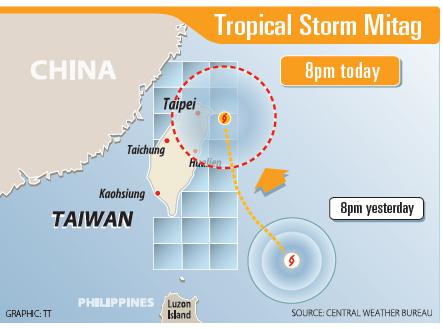
The storm is forecast to move toward the nation’s southeast coast today, bureau Weather Forecast Center specialist Hsieh Ming-chang (謝明昌) said.
Waves off the nation’s eastern and southeastern coasts are likely to become stronger, particularly from this afternoon to tomorrow morning, when the storm would come closer to the nation.
Hsieh said Mitag is likely to be upgraded to a typhoon by the time it starts affecting northern Taiwan, adding that “hotspots” for rainfall from this afternoon to tomorrow morning are in the northern and northeastern regions.
These regions are likely to experience extremely heavy rainfall, which means that accumulated rainfall within 24 hours could reach 200mm.
Residents in low-lying areas might experience flooding due to the combined effects of heavy rainfall and spring tides, the bureau said.
At 10pm last night, the governments in Taipei, New Taipei City, Taoyuan, Keelung and Hsinchu County announced that today would be a typhoon day.
However, as of 9:20pm, the governments in Taichung, Tainan, Kaohsiung and Chiayi City, as well as Changhua, Yunlin, Nantou, Chiayi and Pingtung counties had announced that offices and schools would be open today.
Former Weather Forecast Center director Daniel Wu (吳德榮) said Mitag would move away from Taiwan tomorrow before heading toward South Korea.
Even through the storm’s center appears likely to remain offshore, Wu said that he does not exclude the possibility that it might make landfall.
People should not underestimate the threat the storm poses to the northern and northeastern regions, he said.
From last night to tomorrow morning, Mitag’s circumfluence is expected to bring heavy rain to windward areas, particularly the mountainous areas in the north as well as the nation’s northeast coast, Wu said.
Residents in northern and northeastern regions should be aware of the damage caused by strong winds, he said.
Cloudy skies to showers are forecast for Hualien and Taitung, although residents in Hualien might still experience heavy rainfall, he added.
Meanwhile, heavy rainfall is forecast for the mountainous areas in central Taiwan, he said.
As Mitag is to move away from Taiwan tomorrow afternoon, rainy to cloudy skies are forecast for the northern region, Wu said.
Chances of showers would remain high in the mountainous areas in central and southern Taiwan, as well as in Hualien and Taitung, he said.
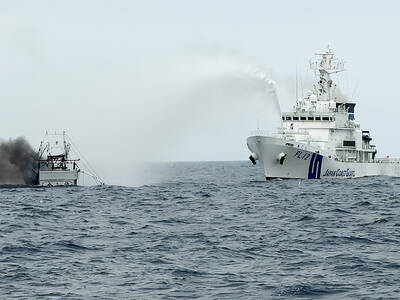
CREDIT-GRABBER: China said its coast guard rescued the crew of a fishing vessel that caught fire, who were actually rescued by a nearby Taiwanese boat and the CGA Maritime search and rescue operations do not have borders, and China should not use a shipwreck to infringe upon Taiwanese sovereignty, the Coast Guard Administration (CGA) said yesterday. The coast guard made the statement in response to the China Coast Guard (CCG) saying it saved a Taiwanese fishing boat. The Chuan Yu No. 6 (全漁6號), a fishing vessel registered in Keelung, on Thursday caught fire and sank in waters northeast of Diaoyutai Islands (釣魚台). The vessel left Keelung’s Badouzih Fishing Harbor (八斗子漁港) at 3:35pm on Sunday last week, with seven people on board — a 62-year-old Taiwanese captain surnamed Chang (張) and six

LEVERAGE: China did not ‘need to fire a shot’ to deny Taiwan airspace over Africa when it owns ‘half the continent’s debt,’ a US official said, calling it economic warfare The EU has raised concerns about overflight rights following the delay of President William Lai’s (賴清德) planned state visit to the Kingdom of Eswatini after three African nations denied overflight clearance for his charter at the last minute. Taiwanese allies Paraguay and Saint Kitts and Nevis, as well as several US lawmakers and the Inter-Parliamentary Alliance on China (IPAC) condemned China for allegedly pressuring the countries. Lai was scheduled to fly directly to Taiwan’s only African ally from yesterday to Sunday to celebrate the 40th anniversary of King Mswati III’s accession and his 58th birthday, but Seychelles, Mauritius and Madagascar suddenly revoked

RISKY BUSINESS: The ‘incentives’ include initiatives that get suspended for no reason, creating uncertainty and resulting in considerable losses for Taiwanese, the MAC said China’s “incentives” failed to sway sentiment in Taiwan, as willingness to work in China hit a record low of 1.6 percent, a Ministry of Labor survey showed. The Directorate-General of Budget, Accounting and Statistics (DGBAS) also reported that the number of Taiwanese workers in China has nearly halved from a peak of 430,000 in 2012 to an estimated 231,000 in 2024. That marked a new low in the proportion of Taiwanese going abroad to work. The ministry’s annual survey on “Labor Life and Employment Status” includes questions respondents’ willingness to seek employment overseas. Willingness to work in China has steadily declined from

The number of pet cats in Taiwan surpassed that of pet dogs for the first time last year, reaching 1,742,033, a 32.8 percent increase from 2023, the Ministry of Agriculture said yesterday, citing a survey. By contrast, the number of pet dogs declined slightly by 1.2 percent over the same period to 1,462,528, the ministry said. Despite the shift, households with dogs still slightly outnumber those with cats by 1.2 percent. However, while the number of households with multiple dogs has remained relatively stable, households keeping more than two cats have increased, contributing to the overall rise in the feline population. The trend