The shaky global economy needs Japan and China to be fully engaged, the head of the IMF said recently, warning the world could not afford to have the two countries distracted by their bitter territorial dispute.
Speaking to Japanese media ahead of the fund’s annual meeting in Tokyo next week, IMF Managing Director Christine Lagarde said the two had to show a bit of neighborly tolerance for the good of everybody.
“Both China and Japan are key economic drivers that do not want to be distracted by territorial division,” Kyodo News agency quoted Lagarde as saying in Washington, in an interview published yesterday.
China and Japan, the world’s second and third-largest economies, have been at loggerheads for months over the Diaoyutai Islands (釣魚台), in the East China Sea.
Tokyo administers the chain under the name Senkakus, but they are also claimed by Beijing and Taipei.
Chinese government ships regularly venture into waters around the islands, ignoring orders to leave from the Japanese coastguard.
Three such maritime surveillance ships entered territorial waters off the islands for the second straight day yesterday, Japanese coast guards said.
The three ships were off Kubashima islet, but left the immediate area soon after 3pm, the Japanese coast guard said.
The increasing frequency of spats comes ahead of next week’s IMF and World Bank meetings in Tokyo — the world’s largest single gathering of finance officials, bankers and non-government organizations.
Dow Jones Newswires reported on Tuesday that several big Chinese banks had canceled their participation in events connected to the meetings, in what it said was a sign of the row spreading into the economic realm.
Most of the banks have not given a reason for their last-minute pullouts, but one unidentified person was explicit:
“Quite frankly, it’s Japan-China relations,” Dow Jones quoted an official at the Tokyo branch of the Agricultural Bank of China as saying.
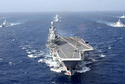
In related news, two of the US Navy’s global force aircraft carrier strike groups are currently patroling the Western Pacific within distance of the South and East China Seas, providing “a combat-ready force that protects and defends the collective maritime interest of the United States and its allies and partners,” the US Seventh Fleet said.
US Navy officials said the USS George Washington carrier strike group had begun operating near the East China Sea while the John C. Stennis Strike Group (JCSSG), led by the USS John C. Stennis carrier, is now operating near the South China Sea, also the scene of sovereignty disputes involving China, Taiwan, Vietnam and the Philippines.
US Pacific Command (PACOM) said the JCSSG paid a scheduled port visit at Kota Kinabalu in Sabah, Malaysia, on Sunday. This was the first visit by a US carrier in Sabah, which adjoins the South China Sea.
In addition, the USS Bonhomme Richard forward-deployed amphibious assault ship, with about 2,000 US Marines on board, is said to be operating in the Philippine Sea.
All three carrier battle groups were in joint live-fire exercises with the Japanese Self-Defense Forces last month near Guam.
A PACOM spokesman said the exercises and deployments were not necessarily related to the Diaoyutais dispute.
PROVOCATIVE: Chinese Deputy Ambassador to the UN Sun Lei accused Japan of sending military vessels to deliberately provoke tensions in the Taiwan Strait China denounced remarks by Japan and the EU about the South China Sea at a UN Security Council meeting on Monday, and accused Tokyo of provocative behavior in the Taiwan Strait and planning military expansion. Ayano Kunimitsu, a Japanese vice foreign minister, told the Council meeting on maritime security that Tokyo was seriously concerned about the situation in the East China and South China seas, and reiterated Japan’s opposition to any attempt to change the “status quo” by force, and obstruction of freedom of navigation and overflight. Stavros Lambrinidis, head of the EU delegation to the UN, also highlighted South China Sea
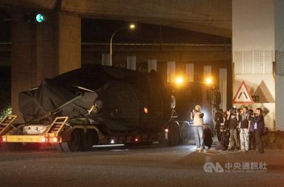
The final batch of 28 M1A2T Abrams tanks purchased from the US arrived at Taipei Port last night and were transported to the Armor Training Command in Hsinchu County’s Hukou Township (湖口), completing the military’s multi-year procurement of 108 of the tanks. Starting at 12:10am today, reporters observed more than a dozen civilian flatbed trailers departing from Taipei Port, each carrying an M1A2T tank covered with black waterproof tarps. Escorted by military vehicles, the convoy traveled via the West Coast Expressway to the Armor Training Command, with police implementing traffic control. The army operates about 1,000 tanks, including CM-11 Brave Tiger
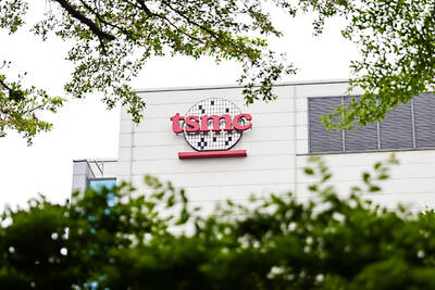
Taiwan Semiconductor Manufacturing Co (TSMC, 台積電), the world’s largest contract chipmaker, said it expects its 2-nanometer (2nm) chip capacity to grow at a compound annual rate of 70 percent from this year to 2028. The projection comes as five fabs begin volume production of 2-nanometer chips this year — two in Hsinchu and three in Kaohsiung — TSMC senior vice president and deputy cochief operating officer Cliff Hou (侯永清) said at the company’s annual technology symposium in Silicon Valley, California, last week. Output in the first year of 2-nanometer production, which began in the fourth quarter of last year, is expected to
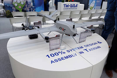
Taiwan’s drone exports surged past US$100 million in the first quarter, exceeding last year’s full-year total, with the Czech Republic emerging as the largest buyer, the Ministry of Economic Affairs said. Exports of complete drones reached US$115.85 million in the period, about 1.2 times the total recorded for all of last year, the ministry said in a report. Exports to the Czech Republic accounted for about US$100 million, far outpacing other markets. Poland, last year’s top destination, recorded about US$11.75 million in the first quarter. Taiwan’s drone exports have expanded rapidly in the past few years, with last year’s total