Sorties by the Chinese navy into the Pacific Ocean are becoming more commonplace and provide it with the means to familiarize itself with the environment surrounding Taiwan, while creating a new front from which to attack in case of conflict, an analyst said.
Four frigates from the People’s Liberation Army Navy (PLAN) were spotted in waters between Miyako Island and Okinawa Island on Friday, the Japanese Ministry of Defense said last week. All four ships, which were tracked by a P-3C patrol aircraft deployed by the Japan Maritime Self-Defense Forces, were traveling from the direction of the East China Sea toward the Pacific Ocean, where they conducted exercises.
The ships — the Type 054A Jiangkai II-class missile frigate Changzhou, the Jiangwei II-class Jiangxing and Lianyungang and the Jiangwei I-class Tongling — stayed in international waters and did not enter Japanese territorial waters, the ministry said.
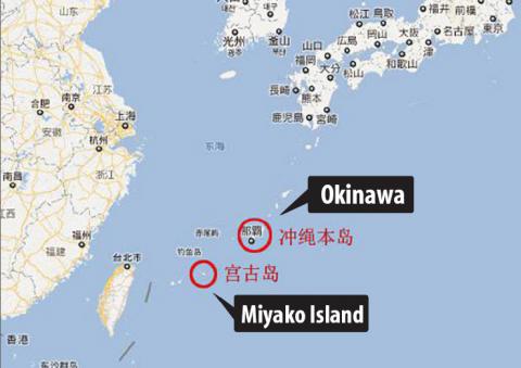
Source: screengrab from Google Map
All the ships, which are part of China’s East Sea Fleet, are equipped with anti-ship and surface-to-air missiles.
The 300km-wide channel between Okinawa and Miyako, known as the Miyako Strait, is regarded as one of the most convenient routes for Chinese vessels heading for the Pacific. Chinese vessels went through it in June 2010 and twice last year as they headed for exercises in the Pacific.
Such sorties have become increasingly commonplace as China’s navy gets more comfortable as an oceangoing navy, James Holmes, an associate professor at the US Naval War College, told the Taipei Times.
Holmes, who recently co-authored a study of the Chinese navy, said the Japanese Defense Ministry was now publishing maps of Chinese naval forays through the Japanese archipelago.
“The maps depict the tracks of PLAN flotillas as though ramen noodles were spilling through the home islands into the Pacific,” he said, adding that in peacetime, China had as much a right as anyone to transit through those waterways, provided they conformed to the restrictions in the Law of the Sea Treaty.
However, asked to discuss the implications for Taiwan’s security, Holmes was less sanguine.
“I have no doubt that the PLAN is familiarizing itself with the operating environment off Taiwan, including the coastal geography and underwater hydrography, and experimenting with tactics for waging war there,” he said.
“Some strategists, myself included, portray [Taiwan’s] rugged eastern coast as a kind of sanctuary for small missile boats and, potentially, submarines,” Holmes said. “It only makes sense for the PLAN to take the measure of the ‘strength and situation’ of a potential enemy before an armed clash.”
Crucially, the PLAN presence in the Pacific enhances its ability to fight all around Taiwan and not just along the west coast, which has been the traditional direction from which a Chinese attack would come, he said.
Miyako is located about 350km east off the northern tip of Taiwan, including Keelung Naval Base. The area also faces Cha Shan Air Base in Hualien.
Such encirclement of Taiwan would greatly complicate its ability to counter a naval attack and could exploit weaknesses in defenses along its east coast, which faces away from China.
“Equally important, by displaying that capability vis-a-vis Taipei and Washington, the navy enhances Beijing’s bargaining power in future dealings across the strait,” Holmes said. The PLA Navy is practicing the skills needed to coerce and deter while helping underwrite Chinese diplomacy in the bargain.”
In related developments, the People’s Liberation Army Daily announced on Tuesday that the recently commissioned Type 071 Jinggangshan landing platform dock under the South China Sea Fleet had conducted its first joint training with helicopters and air cushion boats. At 19,000 tonnes, the Jinggangshan is the heaviest LPD in the PLAN.
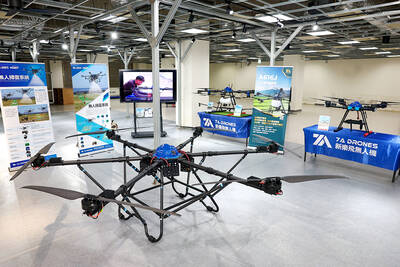
DRONE CENTRAL: Taiwan aims to become Asia’s democratic hub for drones, with most exports focused on high-quality military-grade models, an official said Taiwan’s drone industry is expected to expand significantly by 2030, producing 100,000 units per month and exporting half of them, the Ministry of Economic Affairs said yesterday. Current drone production capacity is about 15,000 units per month, but the industry can quickly scale up as demand increases, Industrial Development Administration Director-General Chiou Chyou-huey (邱求慧) told a news conference in Taipei. Taiwan’s drone output grew 2.5-fold last year to NT$12.9 billion (US$408.3 million) under a government program to develop the uncrewed vehicle sector, he said. The Executive Yuan in October last year approved plans to invest NT$44.2 billion into domestic production of uncrewed aerial
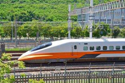
A signaling system malfunction disrupted high-speed rail (HSR) services beginning at 8am today, with trains temporarily reduced to three northbound and three southbound trains per hour as authorities conduct inspections. The malfunction occurred on a section of track in Miaoli County during pre-operation checks early this morning, forcing northbound and southbound trains to use a single track, the HSR operator said. The regular schedule has been replaced with three hourly trains offering only nonreserved seating in each direction, stopping at every station, it said, adding that business class cars would still have reserved seating. Departures from terminal stations are scheduled at the top
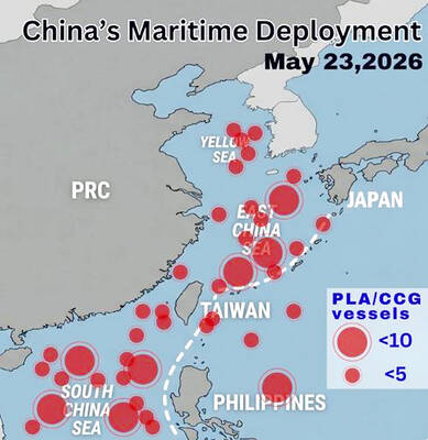
WARNING: China should stop engaging in actions that undermine regional peace and stability, as it would only build resentment among people across the Strait, the CGA said China has deployed more than 100 navy, coast guard and other vessels in waters from the Yellow Sea to the South China Sea and the western Pacific since US President Donald Trump and Chinese President Xi Jinping (習近平) met in Beijing, National Security Council Secretary-General Joseph Wu (吳釗燮) said yesterday. “In this part of the world, #China is the one & only PROBLEM wrecking the #StatusQuo & threatening regional peace & stability,” Wu wrote on X. In a separate post, he said Beijing was coercing Taiwan’s maritime domain, calling it illegal and provocative, after the Coast Guard Administration (CGA) expelled a
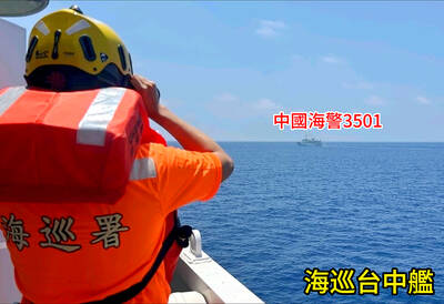
VERBOSE VESSELS: A CGA cutter and a China Coast Guard exchanged verbal barbs for more than a day in Taiwanese-controlled waters before the Chinese vessel left The Taiwanese and Chinese coast guards had a standoff near the strategically located Pratas Islands (Dongsha Islands, 東沙群島) in the north of the South China Sea, the Coast Guard Administration (CGA) said yesterday. The two sides engaged in intense radio exchanges over sovereignty claims during the 33-hour standoff. China Coast Guard vessel 3501 eventually left the restricted waters, 26.6 nautical miles (49.2km) west of the Pratas Islands, at 5pm yesterday, the CGA said. Lying approximately between southern Taiwan and Hong Kong, the Taiwan-controlled Pratas are seen by some security experts as vulnerable to Chinese attack due to their distance — more than