Premier Wu Den-yih (吳敦義) yesterday defended the government after a Cabinet document charting the country’s territorial waters made Kinmen and Matsu appear to be parts of China.
“For 10 years Kinmen and Matsu have been deliberately left out [of the country’s official territorial waters] … Over the last 10 years the issue hasn’t been reviewed,” Wu said, referring to a previous version of the map drawn up in 1999.
Asked whether the government had made a secret deal with China on the issue, Wu dismissed the idea.
“There was no secret deal … There must have been some reason why the situation has remained this way for the past 10 years. It hasn’t changed no matter whether the Chinese Nationalist Party [KMT] or the Democratic Progressive Party [DPP] was in power,” Wu said.
Wu also said that Kinmen and Matsu not being included in the document’s boundary line was in line with the consensus on cross-strait relations — “to set aside disputes and create a win-win situation.”
“Kinmen and Matsu belong to Fujian Province … Although Kinmen and Matsu are under the Republic of China’s [ROC] jurisdiction, other parts of Fujian Province are under the jurisdiction of the mainland,” Wu said.
The furor came about after the Chinese-language Liberty Times (the Taipei Times’ sister newspaper) said the Executive Yuan last Wednesday promulgated the revised regulations on the boundaries of the country’s territorial waters following demarcations defined in 1999 that excluded the Diaoyutai (釣魚台) and Paracel (西沙) islands as well as Kinmen and Matsu.
Although the document was promulgated with Wu’s name on it, Wu told reporters yesterday that “I did not know about it until I read about it in [yesterday’s] newspapers.”
The notice shows the ROC’s territorial waters and contiguous areas extend from Taiwan proper and its immediate offshore islands to include the Diaoyutai Islands (釣魚台) in the Pacific Ocean, the Dongsha Islands (or the Pratas Islands, 東沙島) and Chongsha Bank (or Macclesfield Bank, 中沙群島) in the South China Sea.
The scope of the country’s territorial waters remained the same as announced in 1999, the first time the government made the demarcation based on the ROC Territorial Waters and Neighboring Areas Act (中華民國領海及鄰近區法), which was passed a year earlier.
The Ministry of the Interior, which was in charge of drawing up the document, said the purpose of the revisions was merely a technical fine-tuning to adjust to revised nautical charts after the army replaced its original coordination system with the international coordinate system WGS 84.
Executive Yuan Spokesman Su Jun-pin (蘇俊賓) released a press statement saying the government never considered giving up Kinmen and Matsu.
Presidential Office Spokesman Wang Yu-chi (王郁琦) yesterday said that the administration must include Kinmen and Matsu in “the territory of Taiwan” because they are “Taiwan’s legitimate dominion.”
Wang said Minister of the Interior Jiang Yi-huah (江宜樺) told the legislature’s Judiciary and Organic Laws and Statutes Committee yesterday morning that Kinmen and Matsu would be included in the country’s territorial map within a year.
“Our position is that we should consider Kinmen and Matsu as two regions under the legal rule of Taiwan,” he said.
Wang said they did not know why the sea line around the outlying islets of Kinmen and Matsu was not included in the country’s territory when the government first promulgated the charts in 1999, but noted that the former DPP administration did nothing to change it.
Wang said the two islets would be included the next time the map was drawn up.
Wang said that the Presidential Office or the National Security Council had not played any role in the matter, saying it was “an operation of the Ministry of the Interior.”
CONTINUED ON PAGE 3
When questioned by legislators at an Internal Administration Committee meeting yesterday, Jiang said the government would never give up Kinmen and Matsu and would soon declare the islands Taiwan’s marine territories.
“We have never changed our stance on Kinmen and Matsu — whether in terms of sovereignty or de facto jurisdiction [over the islands],” Jiang told the committee. “It didn’t when we declared our marine territories 10 years ago or … when another party was in power.”
“There is no doubt that Kinmen and Matsu are under the jurisdiction of the Republic of China. We will continue the project of measuring coastlines for basis of marine territorial claim,” Jiang said. “Results from the second phase of the project will be announced in a year.”
Chinese Nationalist Party (KMT) Legislator Lee Ching-hua (李慶華) urged the Executive Yuan to correct the nation’s boundaries.
“Aren’t we going to hold county chiefs elections for Kinmen and Matsu [next month]? How come [the government] did not include them within our territory? This is a very serious mistake and could result in serious problems afterwards,” Lee said.
KMT Legislator Shuai Hua-ming (帥化民) said the government should stipulate the inclusion of Kinmen and Matsu in the nation’s territory in a written document.
The DPP said that leaving the coastline around Matsu and Kinmen out of the country’s official territorial map set a dangerous precedent that would enable China to claim Taiwan as part of its territory.
“The government claimed that this was part of Taiwan’s effort to shelf differences in order to improve cross-strait ties. The problem is, Taiwan’s unilateral action to exclude Kinmen and Matsu’s sea territory will only ignite further conflict between the two sides,” said DPP Lawmaker Yeh Yi-ching (葉宜津), panning the administration for being China-centric while disregarding the livelihood of the Taiwanese, particularly those residing on the offshore islets.
DPP Kaoshiung City Councilor Chao Tien-lin (趙天麟) said that Taiwan and Japan have had a longstanding feud over the Diaoyutais, but that difference of opinion had never deterred Taiwan from including the disputed island chain as part of ROC territory.
“If we are serious about shelving differences with all of our neighbors, then why not also abdicate our claims for the Diaoyutais or Spratly Islands?” Chao said.
Chao added that during the DPP era, the government launched several unofficial negotiations with Beijing on the direct cross-strait flight issue, but that none of the talks came to fruition because Taiwan insisted the flight must be routed either closer to Japan or the Philippines to make them appear international rather than domestic.
Chao said the KMT caved in to Chinese pressure when it came to power because it was too eager to start cross-strait direct flights, adding that the gesture, and alienating Kinmen and Matsu from the territorial map, could all become Beijing’s “evidence” to show the international community that Taiwan has agreed that it is part of China.
Questioned by legislators at an Internal Administration Committee meeting yesterday, Jiang said the government would never give up Kinmen and Matsu and would soon declare the islands Taiwan’s marine territories.
“We have never changed our stance on Kinmen and Matsu — whether in terms of sovereignty or de facto jurisdiction [over the islands],” Jiang told the committee. “It didn’t when we declared our marine territories 10 years ago … when another party was in power.”
“There is no doubt that Kinmen and Matsu are under the jurisdiction of the Republic of China. We will continue the project of measuring coastlines on the basis of marine territorial claim,” Jiang said. “Results from the second phase of the project will be announced in a year.”
Chinese Nationalist Party (KMT) Legislator Lee Ching-hua (李慶華) urged the Executive Yuan to rectify the nation’s boundaries.
“Aren’t we going to hold county chiefs elections for Kinmen and Matsu [next month]? How come [the government] did not include them within our territory? This is a very serious mistake and could result in serious problems afterwards,” Lee said.
KMT Legislator Shuai Hua-ming (帥化民) said the government should stipulate the inclusion of Kinmen and Matsu in the nation’s territory in a written document.
The DPP said that leaving the coastline around Matsu and Kinmen out of the country’s official territorial documents set a dangerous precedent that would enable China to claim Taiwan as part of its territory.
“The government claimed that this was part of Taiwan’s effort to shelve differences in order to improve cross-strait ties. The problem is, Taiwan’s unilateral action to exclude Kinmen and Matsu’s territorial waters will only ignite further conflict between the two sides,” said DPP Lawmaker Yeh Yi-ching (葉宜津), panning the administration for being China-centric while disregarding the livelihood of the Taiwanese, particularly those residing on the offshore islets.
DPP Kaoshiung City Councilor Chao Tien-lin (趙天麟) said that Taiwan and Japan have had a longstanding feud over the Diaoyutais, but that difference of opinion had never deterred Taiwan from including the disputed island chain as part of ROC territory.
“If we are serious about shelving differences with all of our neighbors, then why not also abdicate our claims for the Diaoyutais or Spratly Islands?” Chao said.
Chao added that during the DPP era, the government launched several unofficial negotiations with Beijing on the direct cross-strait flight issue, but that none of the talks came to fruition because Taiwan insisted flights must be routed either closer to Japan or the Philippines to make them appear international rather than domestic.
Chao said the KMT caved in to Chinese pressure after it came to power because it was too eager to start cross-strait direct flights, adding that the gesture, as well as leaving the territorial waters around Kinmen and Matsu out of official documents, could all become Beijing’s “evidence” to show the international community that Taiwan has agreed that it is part of China.
ADDITIONAL REPORTING BY JENNY W. HSU AND FLORA WANG

‘NO SECURITY RISK’: The Railway Bureau reassured the public that the technicians’ activities were limited to technical guidance and did not involve sensitive systems The Railway Bureau yesterday said it had invited eight Chinese technicians to assist with an airport MRT construction project. The bureau issued the confirmation after an Internet user said Chinese nationals had entered the construction zone of Taiwan Taoyuan International Airport’s Terminal 3 project. They asked why “individuals from an enemy state” were allowed access to such a major national infrastructure project, which raised serious concerns over Taiwan’s industrial safety, sensitive systems and information security. The bureau’s Northern Region Engineering Branch Office said subcontractor Taiwan Handle Industrial Co (台灣手把工業) of the Taoyuan airport MRT’s “Contract No. CU05 Project A14 Station Civil, MEP &
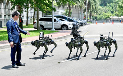
The National Chungshan Institute of Science and Technology yesterday showcased its locally developed variants of the Vision 60 robotic patrol dog, which it plans to deploy on the nation’s outlying territories in the South China Sea. The variants were produced under the Joint Lab project — created by the institute and domestic companies — and assembled with domestically produced motors, lenses and artificial intelligence (AI) systems alongside licensed tech from the US, Missile and Rocket Systems Research Division deputy director Jen Kuo-kang (任國光) told the media event at a military base in Taipei’s Dazhi (大直) area. Taiwan has built up its strengths
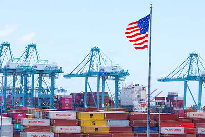
NOT IMMEDIATE: Taiwan has a chance to appeal the proposed 10 percent tariff before it starts, while other countries face a 12.5 percent tariff from the trade office Taiwan is among 60 economies determined by the US to have failed to impose or enforce a ban on the importation of goods produced with forced labor, according to a notice released on Tuesday by the Office of the US Trade Representative (USTR), which proposed imposing an additional 10 percent or more tariff on them. The USTR in a statement said that following an investigation, it had determined under Section 301 of the Trade Act of 1974 that the failure of the 60 economies to impose and effectively enforce a prohibition on the importation of goods produced with forced labor is
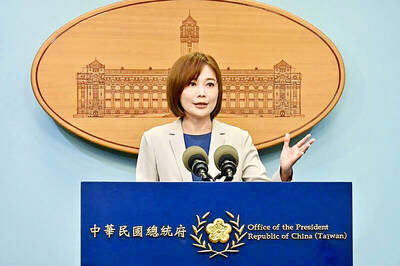
TIT-FOR-TAT: The US allegedly revoked the visa of a Chinese national working at Xinhua News Agency in the US in response to Beijing’s expulsion of Vivian Wang The Presidential Office yesterday condemned China for expelling a New York Times correspondent from Beijing following the newspaper’s interview with President William Lai (賴清德), saying the move highlighted Beijing’s suppression of press freedom and its threat to international news media. Taiwan has noted a series of recent incidents in which Beijing used similar tactics to “threaten and pressure international media outlets and journalists,” Presidential Office spokeswoman Karen Kuo (郭雅慧) said in a statement. “This concerns not only press freedom and freedom of expression, but also the safety of journalists, and Taiwan and relevant partners are paying close attention to the situation,” she