Explosions at one of Britain's largest oil depots jolted an area north of London early yesterday, hurling balls of fire skyward, shattering windows and blanketing nearby houses with smoke.
The blasts appeared to be accidental. Thirty-six people were injured, four seriously, police said.
Explosions were expected to continue for several hours at the depot, which stores 16 million liters of fuel, police said.
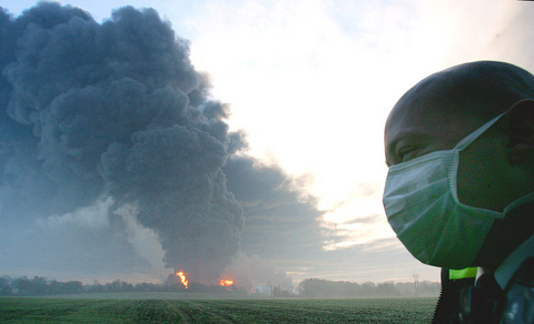
PHOTO: AP
"It's big and it's going to burn for some time," said Frank Whiteley, chief constable of Hertfordshire Police. "But it is under control."
There was nothing to indicate the blasts were acts of terrorism, police said, although the al-Qaeda terror network and other terrorist groups have threatened to target fuel deposits. Britain has been on edge since the July 7 London transit bombings, which killed 56 people including four suicide bombers, and a failed attack on July 21.
Some residents reported hearing an aircraft flying low overhead shortly before the first explosion at around 6am but police said there was no evidence of a plane crash. Nearby Luton Airport remained open and flights were operating normally.
"All indications at this stage are that this was an accident," Whiteley said. "However, clearly we will keep an open mind, as with all investigations, until we can confirm that for certain."
Firefighters planned to use foam to stop the blaze spreading across the 450m by 850m depot and adjacent industrial park. The 20 blazing tanks were being allowed to burn themselves out while about 100 firefighters and 100 police officers stood watch at the site.
"It's a controlled burn," said Jane Vine, a spokeswoman for the local county council.
Emergency workers wearing masks cordoned off the area around the Buncefield Oil Terminal, near the town of Hemel Hempstead. Authorities evacuated residents as the plume moved slowly eastward.
Whiteley cautioned that the cloud contained irritants that could cause coughs and nausea. People in the path of the smoke should stay indoors, he said.
Residents in Hemel Hempstead reported a loud boom and some felt their houses shake. The blast was so large it was felt throughout a large part of southeast England including London, 40km away.
"Around 6am, as we were sleeping, there was a mighty explosion -- a thunderclap that woke me up," said Neil Spencer, 42, who lives about 1 1/2km from the terminal. "It was fireball after fireball -- truly amazing."
The area around the fuel depot was being evacuated. Police said many roads and highways had been closed.
‘NO SECURITY RISK’: The Railway Bureau reassured the public that the technicians’ activities were limited to technical guidance and did not involve sensitive systems The Railway Bureau yesterday said it had invited eight Chinese technicians to assist with an airport MRT construction project. The bureau issued the confirmation after an Internet user said Chinese nationals had entered the construction zone of Taiwan Taoyuan International Airport’s Terminal 3 project. They asked why “individuals from an enemy state” were allowed access to such a major national infrastructure project, which raised serious concerns over Taiwan’s industrial safety, sensitive systems and information security. The bureau’s Northern Region Engineering Branch Office said subcontractor Taiwan Handle Industrial Co (台灣手把工業) of the Taoyuan airport MRT’s “Contract No. CU05 Project A14 Station Civil, MEP &
A US uncrewed surface vessel (USV) encountered multiple Chinese warships during an autonomous transit of the Taiwan Strait, US defense company Seasats said in a statement on Wednesday. Seasats announced that a Lightfish USV had completed the first autonomous transit of the Taiwan Strait. Over five days, the USV traversed the entire length of the Strait while constantly monitoring surface vessel traffic, the company said. The Lightfish encountered multiple Chinese warships, one of which was a Chinese People’s Liberation Army Navy (PLAN) Type 056 corvette, it said. The Chinese vessels were operating “well within Taiwan’s exclusive economic zone without transmitting their identity via the
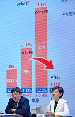
GREATER REACH? Auto parts and wood products would face tariffs of up to 15%, matching those targeting the EU, Japan and South Korea, Vice Premier said The US has announced that preferential tariff treatment for Taiwan’s non-semiconductor Section 232 goods would take effect retroactively from May 1, the Executive Yuan said yesterday. The US government yesterday posted a notice on the Federal Register’s public inspection Web site previewing tariff concessions for Taiwan under a memorandum of understanding (MOU) on Taiwan-US investment after two months of negotiations. The MOU signed on Jan. 15 stipulated three major preferential tariff arrangements: a 15 percent “reciprocal” tariff rate for Taiwan without stacking most-favored nation (MFN) rates; preferential Section 232 treatment for semiconductors and related products; and preferential Section 232 treatment for non-semiconductor
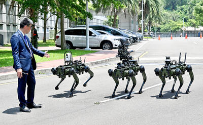
The National Chungshan Institute of Science and Technology yesterday showcased its locally developed variants of the Vision 60 robotic patrol dog, which it plans to deploy on the nation’s outlying territories in the South China Sea. The variants were produced under the Joint Lab project — created by the institute and domestic companies — and assembled with domestically produced motors, lenses and artificial intelligence (AI) systems alongside licensed tech from the US, Missile and Rocket Systems Research Division deputy director Jen Kuo-kang (任國光) told the media event at a military base in Taipei’s Dazhi (大直) area. Taiwan has built up its strengths