A couple of decades ago, Jhueilu Old Trail (錐鹿古道) exerted an almost mythical allure to many Taiwanese hikers, although it was unknown to most other visitors to Taroko Gorge. Only a relatively small number of experienced hikers could cope with the difficult river crossing at the beginning, the overgrown paths and (at the most famous section) the death-defyingly narrow sections of the cliff trail, which were said to have been only a foot or so wide.
Then the 921 Earthquake struck, damaging parts of the trail and closing it to all for nearly a decade. When it finally reopened in July 2008, it had been given a major overhaul to make it safer and easier to follow. The trails were cleared, signs installed, a long suspension bridge erected (which made the river crossing at the start much easier) and the narrowest parts of the cliff-edge trail were widened.
As soon as it was reopened, the trail naturally became a hugely popular weekend destination. And a decade later, the trail — probably the finest day hike on the island — seems more popular than ever.
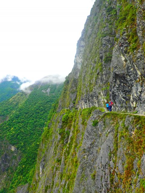
Photo: Richard Saunders
The 10.3km Jhueilu Old Trail, which in its entirety makes a magnificent six to seven-hour hike, is renowned for a five hundred meter-long stretch near its eastern end which is, astonishingly, cut into Taroko Gorge’s highest and sheerest cliff face.
The vertical precipice plunges vertically for over 450m from the edge of the trail to the road and the Liwu River (立霧溪), far, far below. Walking along this precarious perch nearly half a kilometer above the river remains an unforgettable experience.
Halfway along the cliff face, the trail dives into a short tunnel, near the start of which is a tiny shrine housed in a hollow carved out of the cliff. It’s not hard to imagine travelers stopping here to pray for a safe traverse.
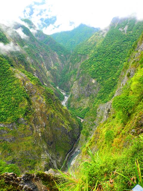
Photo: Richard Saunders
Jhueilu Old Trail is just a small section of a 145km-long trail, cut by the Japanese between 1914 and 1933. The route links Taroko Gorge with the village of Wushe (霧社), over the mountains in today’s Nantou County, and was part of an attempt to open up the island’s central mountains and subdue the indigenous inhabitants there. Another short stretch of the original trail, now called the Lushui Trail (綠水步道) can also still be followed, but it’s not nearly as magnificent.
Although there are two trailheads, the western part of the trail was closed again several years ago, and seems unlikely to reopen anytime soon. In case it does reopen, the trail leaves the road on the east side of Zihmu Bridge (慈母橋), scrambles up a boulder-strewn tributary stream for a short distance, then veers away from it, beginning a long gain in altitude and passing through a tunnel before it suddenly re-emerges on the side of the gorge at the first stretch of cliff path.
Nowadays, everyone has to start at the other trailhead, which lies beside the mouth of the tunnel at the eastern end of Swallow Grotto (燕子口) in the central section of Taroko Gorge. This is marked by a locked gate and a long and graceful suspension bridge that spans the chasm high above the waters (and is a great improvement on the series of makeshift bridges that took hikers across the Liwu River here pre-1999, and which were regularly destroyed by typhoon floodwaters).
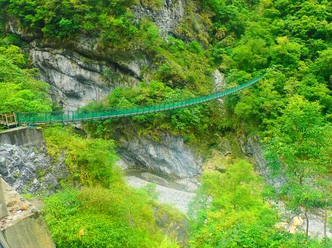
Photo: Richard Saunders
Not quite so welcome, perhaps, are the steps that climb the steep side of the gorge on the far side of the river. Every few meters, small signs warn of all manner of risks to be faced on the trail, from unstable ground and slippery rocks to poisonous bees and snakes, and an amusing sign at the beginning of the trail, which states that the path is of “a high level of difficulty” and is, in parts “potentially very dangerous.”
The trail is in fact well made, if a tad monotonous, and the 500 meters of vertical ascent is achieved painlessly. It helps having a few spots of interest on the way.
Just after the one kilometer marker (the trail is marked with distance posts every 100 meters) is the site of the vanished settlement of Badagang (巴達岡), which in Japanese times boasted a clinic, a school and several inns for travelers passing through on foot. Two hundred meters after it is a rather innocuous-looking suspension bridge that actually spans a narrow but gaping chasm with a drop of nearly a 100 meters.
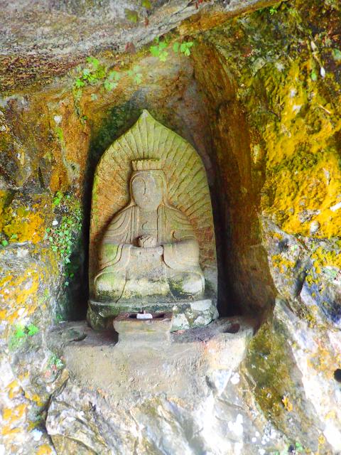
Photo: Richard Saunders
Few do this hike to enjoy the remains of old villages or suspension bridges, however, so most hikers just carry on upwards until, around the 2.5km point, it flattens out, the view opens up and the cliff section draws close.
Passing through a short tunnel, the path narrows, the ground on the left begins to fall away steeply and the great cliff (and the path cut into its prodigious face) appears ahead.
For the next 500 meters the path is squeezed between the vertical face of the cliff above, and a huge, similarly sheer drop below. It is an airy, exposed and thrilling ledge with astounding views over the central section of Taroko Gorge, nearly half a kilometer below and the high mountains rearing above and behind it.
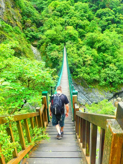
Photo: Richard Saunders
The spectacle is mesmerizing, so take time to walk this 500 meter-long final stretch. At the far end is a small area of flat ground shaded by trees (the site of an old Japanese police post).
If the remainder of the trail ever reopens, it’s another seven rough kilometers (including a couple more magnificent cliff sections, almost but not quite as spectacular as this first) before the trail emerges at Zihmu Bridge. It’s no hardship retracing the outward route back to Swallow Grotto, however, as this allows hikers to experience the amazing cliff trail, and its incomparable views, for a second time.

Ajay Verma, a consultant gastroenterologist at Kettering general hospital in Northamptonshire, says our gut is a “complex machine.” “It is constantly providing us with the nutrition we need, initially to grow and develop, and then for us to survive, thrive and repair from injury and illness.” How can we keep it functioning well? Put simply: “Make sure what you put into it is balanced, and that you clear out its waste products adequately,” Verma says. “In a general gastroenterology clinic, the most common conditions we see are irritable bowel syndrome (IBS), gastroesophageal reflux disease, inflammatory bowel disease and constipation,” says Nisha
The arithmetic is straightforward and uncomfortable. By the end of 2025, Taiwan had committed itself to a 50-30-20 electricity mix — half natural gas, 30 per cent coal, 20 per cent renewables. The Ministry of Economic Affairs’s (MOEA) own monthly energy reports tell a different story. Natural gas reached 47.8 per cent of generation last year. Coal stood at 35.4 per cent, comfortably above its target ceiling. Renewables came in at 13.1 per cent, well short of the 20 per cent Taipei had pledged a decade earlier. Installed renewable capacity reached roughly half of the 12 gigawatts (GW) the government

Last week US President Donald Trump was asked by a reporter whether he would speak on the phone to the President of Taiwan. “l’ll speak to him. I speak to everybody. We have that situation very well in hand,” Trump said. This marked the second time in a couple of weeks he had said he would talk to the President of Taiwan. In 2016 he famously took a call from then-president Tsai Ing-wen (蔡英文), when he was president-elect. Despite warnings that the apocalypse was nigh because of a phone call, the world quickly forgot about the conversation between two democratically-elected presidents.
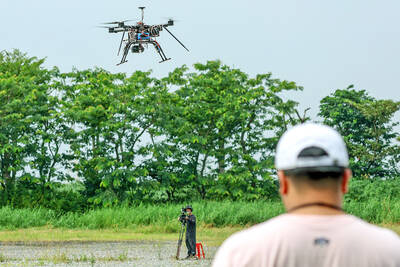
Taiwan’s drone exports are taking off, fuelled by the war in Ukraine, as Taiwanese companies seek a stake in the fast-growing global market for unmanned aerial vehicles (UAV). Low-cost drones used for reconnaissance and strikes are in high demand as governments around the world boost defense spending in the face of intensifying conflicts. A relative new player in the increasingly competitive industry, Taiwan’s pitch is to be an “Asian hub” for the production of UAVs and components free of Chinese materials, or “non-red.” That means its UAVs can be up to three times more expensive than their Chinese competitors, like the world’s biggest