The world at your fingertip, with the click of a computer mouse.
That's what Internet giant Google is offering Windows users in a new program allowing Web surfers to fly around the world in a matter seconds, hopping from one destination to another across the sky.
In "Google Earth," a user can download a picture of Earth, pick a spot on the planet and navigate through satellite and airplane photos of cities.
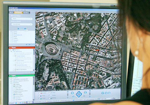
PHOTO: AFP
The resolution of images is clear enough to recognize major landmarks, such as Beijing's Forbidden City. You can zoom in as close as 300m from the ground and recognize clusters of people.
If Rome's coliseum is your next choice, you can watch the screen fly over the snowy Himalayan mountain chain, the Caspian Sea and Istanbul.
The program, downloadable free at www.earth.google.com, uses broadband streaming technology and three-dimensional (3D) graphics, "much like a video game," according to Google.
The California company focused more on the US than other places, but mapping out Europe is a "very high priority," said John Hanke, general manager of Keyhole, whose company was acquired by Google and came up with the technology.
In Britain and North America, the technology gives the latitude and longitude of an address. It can even pinpoint to a precise address by searching some buildings by name.
In the US, 38 cities can be seen in 3D, a feature that has piqued the interest of real-estate agents, Hanke said.
The Web site housingmaps.com, which uses Google maps, offers satellite images of places for sale and rent.
Google sells versions of the program for commercial use at US$400 per year, but Google Earth will not be a big source of revenue until the company uses it to sell advertising space. "We will incorporate advertising at some point in the future," Hanke said.
Scott Kessler, an equity analyst who follows Google for Standard and Poor's, said the program was "really neat."
With the program, Kessler said, "They show their users that they are a global company and have a global brand."
"Over time, the most substantial growth is going to come from outside the US," he said.
Gary Price, an editor at SearchEngineWatch.com, said it was a "cool application, which continues to make people think that Google is doing cool things."
Price was impressed with the quantity of aerial images, but he noted that the technology was not new as Microsoft has offered satellite imagery of the US on Terra-Server for years.
"I'm not sure it's a breakthrough," he said.
Microsoft has created MSN Virtual Earth, found at www.virtualearth.msn.com, which shows aerial images of locations that can be searched.
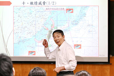
RETHINK? The defense ministry and Navy Command Headquarters could take over the indigenous submarine project and change its production timeline, a source said Admiral Huang Shu-kuang’s (黃曙光) resignation as head of the Indigenous Submarine Program and as a member of the National Security Council could affect the production of submarines, a source said yesterday. Huang in a statement last night said he had decided to resign due to national security concerns while expressing the hope that it would put a stop to political wrangling that only undermines the advancement of the nation’s defense capabilities. Taiwan People’s Party Legislator Vivian Huang (黃珊珊) yesterday said that the admiral, her older brother, felt it was time for him to step down and that he had completed what he

Taiwan has experienced its most significant improvement in the QS World University Rankings by Subject, data provided on Sunday by international higher education analyst Quacquarelli Symonds (QS) showed. Compared with last year’s edition of the rankings, which measure academic excellence and influence, Taiwanese universities made great improvements in the H Index metric, which evaluates research productivity and its impact, with a notable 30 percent increase overall, QS said. Taiwanese universities also made notable progress in the Citations per Paper metric, which measures the impact of research, achieving a 13 percent increase. Taiwanese universities gained 10 percent in Academic Reputation, but declined 18 percent
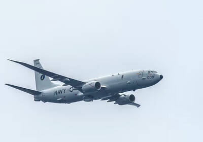
CHINA REACTS: The patrol and reconnaissance plane ‘transited the Taiwan Strait in international airspace,’ the 7th Fleet said, while Taipei said it saw nothing unusual The US 7th Fleet yesterday said that a US Navy P-8A Poseidon flew through the Taiwan Strait, a day after US and Chinese defense heads held their first talks since November 2022 in an effort to reduce regional tensions. The patrol and reconnaissance plane “transited the Taiwan Strait in international airspace,” the 7th Fleet said in a news release. “By operating within the Taiwan Strait in accordance with international law, the United States upholds the navigational rights and freedoms of all nations.” In a separate statement, the Ministry of National Defense said that it monitored nearby waters and airspace as the aircraft

UNDER DISCUSSION: The combatant command would integrate fast attack boat and anti-ship missile groups to defend waters closest to the coastline, a source said The military could establish a new combatant command as early as 2026, which would be tasked with defending Taiwan’s territorial waters 24 nautical miles (44.4km) from the nation’s coastline, a source familiar with the matter said yesterday. The new command, which would fall under the Naval Command Headquarters, would be led by a vice admiral and integrate existing fast attack boat and anti-ship missile groups, along with the Naval Maritime Surveillance and Reconnaissance Command, said the source, who asked to remain anonymous. It could be launched by 2026, but details are being discussed and no final timetable has been announced, the source