South American meteorologists are getting a boost from space: A US weather satellite long used for tracking hurricanes and other wild weather will soon be moved over a continent plagued by its own costly natural disasters.
In October, the US National Oceanic and Atmospheric Administration (NOAA) plans to reposition an aging but reliable nine-year-old satellite high over the Brazilian Amazon to provide full-time coverage for forecasters who now weather long periods without regular images during US hurricane season.
The satellite -- a sport utility vehicle-sized piece of equipment now hovering about 35,881km above the Pacific Ocean -- is part of the Geostationary Operational Environmental Satellite (GOES) series, which has brought Americans views of Hurricane Katrina, El Nino-fueled storms and other meteorological phenomena.
The satellite aid to South America and another that was repositioned in 2003 to get a better view of Japan are NOAA's contributions to improving the Global Earth Observation System of Systems, a coalition of more than 60 countries working to unify Earth observation by 2015 and improve environmental policies around the planet.
"We hope it sets an example for South America and others to share their observations to make our total global forecasting work a little better," said Gregory Withee, assistant administrator of NOAA Satellites and Information Services. "We're all in this together ... because weather is global."
The satellites deliver both visual and infrared images, and are used to monitor storms, detect sea surface temperatures and wildland fires. They also can take cloud temperatures, show ozone distribution and track the conditions that can produce aircraft icing.
South America has received images from existing GOES-series satellites for decades, but those have focused primarily on the US and its immediate surroundings. So whenever a storm kicks up in the Northern Hemisphere, the satellite that usually delivers images to South America at least every 30 minutes instead rapidly scans the northern trouble spot, reducing South American images to as little as once every three hours.
During US hurricane season, this happens as much as 40 percent of the time, NOAA officials said.
In weather terms, such gaps can be an "eternity," said 1st Lieutenant Ricardo Valenti, who oversees a roomful of Air Force and civilian contractors tracking weather at the Argentine National Meteorological Service.
"We can't monitor what we can't see," Valenti said. "There's no anger. We accept that it's like this. But that's why we made the request."
Last year, South American meteorologists formally requested that the satellite be repositioned, rather than the more likely scenario of keeping it as an in-orbit spare after the launch later this spring of the 13th GOES-series satellite, which will continue monitoring US storms.
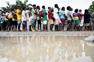
SEEKING CHANGE: A hospital worker said she did not vote in previous elections, but ‘now I can see that maybe my vote can change the system and the country’ Voting closed yesterday across the Solomon Islands in the south Pacific nation’s first general election since the government switched diplomatic allegiance from Taiwan to Beijing and struck a secret security pact that has raised fears of the Chinese navy gaining a foothold in the region. The Solomon Islands’ closer relationship with China and a troubled domestic economy weighed on voters’ minds as they cast their ballots. As many as 420,000 registered voters had their say across 50 national seats. For the first time, the national vote also coincided with elections for eight of the 10 local governments. Esther Maeluma cast her vote in the
Nearly half of China’s major cities are suffering “moderate to severe” levels of subsidence, putting millions of people at risk of flooding, especially as sea levels rise, according to a study of nationwide satellite data released yesterday. The authors of the paper, published by the journal Science, found that 45 percent of China’s urban land was sinking faster than 3mm per year, with 16 percent at more than 10mm per year, driven not only by declining water tables, but also the sheer weight of the built environment. With China’s urban population already in excess of 900 million people, “even a small portion
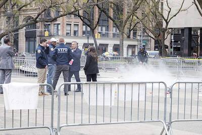
UNSETTLING IMAGES: The scene took place in front of TV crews covering the Trump trial, with a CNN anchor calling it an ‘emotional and unbelievably disturbing moment’ A man who doused himself in an accelerant and set himself on fire outside the courthouse where former US president Donald Trump is on trial has died, police said yesterday. The New York City Police Department (NYPD) said the man was declared dead by staff at an area hospital. The man was in Collect Pond Park at about 1:30pm on Friday when he took out pamphlets espousing conspiracy theories, tossed them around, then doused himself in an accelerant and set himself on fire, officials and witnesses said. A large number of police officers were nearby when it happened. Some officers and bystanders rushed

HYPOCRISY? The Chinese Ministry of Foreign Affairs yesterday asked whether Biden was talking about China or the US when he used the word ‘xenophobic’ US President Joe Biden on Wednesday called for a hike in steel tariffs on China, accusing Beijing of cheating as he spoke at a campaign event in Pennsylvania. Biden accused China of xenophobia, too, in a speech to union members in Pittsburgh. “They’re not competing, they’re cheating. They’re cheating and we’ve seen the damage here in America,” Biden said. Chinese steel companies “don’t need to worry about making a profit because the Chinese government is subsidizing them so heavily,” he said. Biden said he had called for the US Trade Representative to triple the tariff rates for Chinese steel and aluminum if Beijing was