Mount Everest, the world's highest peak, stands 8,844.43m above sea level, some four meters shorter than previously thought, according to the latest survey by Chinese scientists.
The latest measurement was made by a team jointly organized by the Chinese Academy of Sciences (CAS) and the State Bureau of Surveying and Mapping (SBSM), Chen Bangzhu, director general of the bureau, told journalists yesterday.
New height
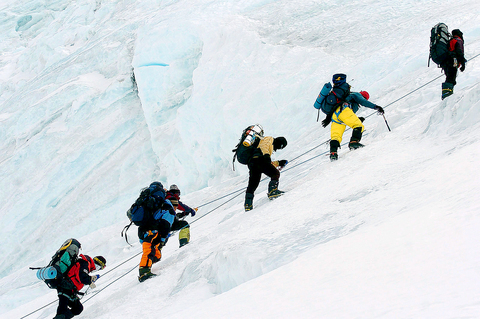
PHOTO: AP
The new height compares with China's previous measurement of Mount Qomolangma -- the traditional Tibetan name of the mountain -- of 8,848.13m which was carried out in 1975.
"This time the final measurement of Qomolangma is slightly lower than that of the 1975 measurement," Chen said.
"Actually the Qomolangma region is a place where the earth's crust is moving, but the new measurement that we have announced is based on the height of the peak's rock surface.
"Before we were unable to measure the height of the rock surface, this time we measured the thickness of the ice to get the actual height of the rock surface."
Chen said the accuracy of the measurement had a range of plus or minus 0.21m, while the thickness of the ice at the summit was measured at 3.5m.
China used the latest technology in measuring the mountain, including satellite equipment belonging to the Global Positioning System (GPS), he said.
The newest measurement also differs from a measurement taken six years ago by US scientists also using GPS satellite equipment that found the height of the mountain at 8,850m.

Republican US lawmakers on Friday criticized US President Joe Biden’s administration after sanctioned Chinese telecoms equipment giant Huawei unveiled a laptop this week powered by an Intel artificial intelligence (AI) chip. The US placed Huawei on a trade restriction list in 2019 for contravening Iran sanctions, part of a broader effort to hobble Beijing’s technological advances. Placement on the list means the company’s suppliers have to seek a special, difficult-to-obtain license before shipping to it. One such license, issued by then-US president Donald Trump’s administration, has allowed Intel to ship central processors to Huawei for use in laptops since 2020. China hardliners

Conjoined twins Lori and George Schappell, who pursued separate careers, interests and relationships during lives that defied medical expectations, died this month in Pennsylvania, funeral home officials said. They were 62. The twins, listed by Guinness World Records as the oldest living conjoined twins, died on April 7 at the Hospital of the University of Pennsylvania, obituaries posted by Leibensperger Funeral Homes of Hamburg said. The cause of death was not detailed. “When we were born, the doctors didn’t think we’d make 30, but we proved them wrong,” Lori said in an interview when they turned 50, the Philadelphia Inquirer reported. The
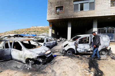
RAMPAGE: A Palestinian man was left dead after dozens of Israeli settlers searching for a missing 14-year-old boy stormed a village in the Israeli-occupied West Bank US President Joe Biden on Friday said he expected Iran to attack Israel “sooner, rather than later” and warned Tehran not to proceed. Asked by reporters about his message to Iran, Biden simply said: “Don’t,” underscoring Washington’s commitment to defend Israel. “We are devoted to the defense of Israel. We will support Israel. We will help defend Israel and Iran will not succeed,” he said. Biden said he would not divulge secure information, but said his expectation was that an attack could come “sooner, rather than later.” Israel braced on Friday for an attack by Iran or its proxies as warnings grew of
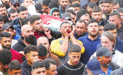
IN PURSUIT: Israel’s defense minister said the revenge attacks by Israeli settlers would make it difficult for security forces to find those responsible for the 14-year-old’s death Israeli Prime Minister Benjamin Netanyahu on Saturday condemned the “heinous murder” of an Israeli teenager in the occupied West Bank as attacks on Palestinian villages intensified following news of his death. After Benjamin Achimeir, 14, was reported missing near Ramallah on Friday, hundreds of Jewish settlers backed by Israeli forces raided nearby Palestinian villages, torching vehicles and homes, leaving at least one villager dead and dozens wounded. The attacks escalated in several villages on Saturday after Achimeir’s body was found near the Malachi Hashalom outpost. Agence France-Presse correspondents saw smoke rising from burned houses and fields. Mayor Amin Abu Alyah, of the