Officials warned about a million residents and tourists along Flo-rida's Gulf Coast to get out of the way of Hurricane Charley, saying parts of Tampa's downtown and nearby areas could be submerged by the massive storm surge likely when the hurricane was expected to strike yesterday.
"It does have the potential of devastating impact ... This is a scary, scary thing," Florida Governor Jeb Bush said on Thursday.

PHOTO: AP PHOTO
The evacuation zone stretched along Florida's west coast from Key West to north of Tampa.
Charley was expected to pass west of the Keys at Florida's tip early yesterday before hitting the Tampa Bay area in the afternoon with winds up to 193kph, heavy rain, tornadoes and the dangerous storm surge, said Hugh Cobb, a meteorologist at the National Hurricane Center in Miami. With winds that high, it would be a powerful Category 3 hurricane.
Radar showed the first rain bands hitting the lower Keys on Thursday night.
Residents of the Tampa Bay area, where the eye is projected to hit, southward to the Naples area were told to expect a storm surge of 3m to 4m. State meteorologist Ben Nelson said the surge could reach 4.8m in the Tampa area if Charley reaches 193kph wind.
The bulk of the evacuations were in Hillsborough and Pinellas counties, which include Tampa and St. Petersburg, a city that sits on a peninsula.
All residents of MacDill Air Force Base, on another peninsula in Tampa Bay, were ordered out, with only essential personnel remaining. MacDill is home to US Central Command, the nerve center of the war in Iraq.
"There will be a period of time where if you stay behind and you change your mind and you want to be rescued, no one can help you. We aren't going to go out on a suicide mission," Pinellas Emergency Management Chief Gary Vickers told people in the evacuation zone.
Heavy traffic flowed across the three Tampa Bay bridges linking Pinellas with Hillsborough and the mainland. Officials worried about traffic jams yesterday morning.
"The highway system was never designed to move this many people this quickly," state emergency management director Craig Fugate said.
Charley became a Caribbean hurricane on Wednesday, moving past Jamaica and over the Cayman Islands. At 2am yesterday (2pm in Taiwan), the hurricane's eye was over Cuba, 22.5km west of downtown Havana.
Forecasters said Charley had top sustained winds of about 169kph. It was moving north-northwest at about 22.5kph and was expected to strengthen, meteorologists said.
Charley roared across Cuba early yesterday, battering Havana with high winds and heavy rans before taking aim on the western coast of Florida.
Charley began pummeling the Isle of Youth off the main island's southwestern coast with heavy rains and high winds on Thursday afternoon. Cuban and US forecasters said storm surge flooding of up to 4.5m was expected along Cuba's southern shores.
Rainfall totals of up to 20cm and related flash flooding was considered likely where Charley hits.
There were no immediate reports of casualties or damage.
More than 149,000 people were evacuated in western and central Cuba as the storm approached and Havana's international airport was closed, along with major seaports, Cuba's official National Information Agency reported.
Only minimal damage was reported in the Caymans Islands, where Charley hit earlier on Thursday when it was a much weaker Category 1 storm. In Jamaica, a man was killed as he disappeared trying to rescue six other people from rising flood waters on Wednesday night.
Charley bore down after Tropical Storm Bonnie's disorganized center sloshed ashore on Thursday morning on the central Florida Panhandle with winds estimated near 80kph. Bonnie failed to produce any flooding rains, but some strong squalls were reported. It weakened into a depression and was no longer a threat as it moved into southern Georgia, Cobb said.
The one-two punch of tropical weather was highly unusual. Storms have not struck so close together in Florida since 1906.
About 6.5 million of Florida's 17 million residents were in Charley's projected path, the US Census Bureau reported.
Many residents prepared for the worst, buying plywood to board up homes and stocking up on water, canned food and batteries to ride out the hurricane.

Republican US lawmakers on Friday criticized US President Joe Biden’s administration after sanctioned Chinese telecoms equipment giant Huawei unveiled a laptop this week powered by an Intel artificial intelligence (AI) chip. The US placed Huawei on a trade restriction list in 2019 for contravening Iran sanctions, part of a broader effort to hobble Beijing’s technological advances. Placement on the list means the company’s suppliers have to seek a special, difficult-to-obtain license before shipping to it. One such license, issued by then-US president Donald Trump’s administration, has allowed Intel to ship central processors to Huawei for use in laptops since 2020. China hardliners

DISADVANTAGE: Erin O’Toole, who led the Conservatives during the election campaign in 2021, estimated that the interference cost his party as many as nine legislative seats Canada’s domestic spy agency on Monday concluded that China interfered in the past two elections, an official probe heard, the firmest evidence so far of suspected Chinese meddling in Canadian politics. Canadian Prime Minister Justin Trudeau’s Liberal Party won both the elections, held in 2019 and 2021. Under pressure from opposition lawmakers unhappy about media reports on China’s possible role, Trudeau set up a commission into foreign interference. The commission was shown a slide on Monday containing an extract of a briefing in February last year from the Canadian Security Intelligence Service (CSIS). “We know that the PRC [People’s Republic of China] clandestinely
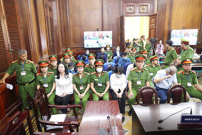
A top Vietnamese property tycoon was on Thursday sentenced to death in one of the biggest corruption cases in history, with an estimated US$27 billion in damages. A panel of three hand-picked jurors and two judges rejected all defense arguments by Truong My Lan, chair of major developer Van Thinh Phat, who was found guilty of swindling cash from Saigon Commercial Bank (SCB) over a decade. “The defendant’s actions ... eroded people’s trust in the leadership of the [Communist] Party and state,” read the verdict at the trial in Ho Chi Minh City. After the five-week trial, 85 others were also sentenced on

‘DELUSIONAL’: Targeting the families of Hamas’ leaders would not push the group to change its position or to give up its demands for Palestinians, Ismail Haniyeh said Israeli aircraft on Wednesday killed three sons of Hamas’ top political leader in the Gaza Strip, striking high-stakes targets at a time when Israel is holding delicate ceasefire negotiations with the militant group. Hamas said four of the leader’s grandchildren were also killed. Ismail Haniyeh’s sons are among the highest-profile figures to be killed in the war so far. Israel said they were Hamas operatives, and Haniyeh accused Israel of acting in “the spirit of revenge and murder.” The deaths threatened to strain the internationally mediated ceasefire talks, which appeared to gain steam in recent days even as the sides remain far