A farmer, his face tan and riven with creases of age, bent over and hoed the soil while a cigarette dangled from his mouth.
He was preparing a hard-packed, stubborn plot of earth for ginger, some of which he would sell to the caravans of students and families that walked this section of the Tsaoling Historic Trail.
Noticing that we were watching him, a bit mystified as to what he was planting, he slowly straightened his bent frame, then quickly wandered over holding a stubby piece of ginger in fingers that looked as gnarled as the root itself.
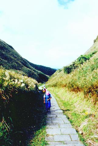
PHOTO: MIKE CLENDENIN, TAIPEI TIMES
"Do you want to buy some," he asked with a gummy grin.
No, we said, but inquired as to what all the PVC tubing was for that lay scattered about.
He took a painfully long time to explain, grinning and gumming his cigarette the entire time, waving his arm across the field occasionally, before asking again good-naturedly if we wanted any ginger, or perhaps some other medicinal roots that he grew within the PVC.
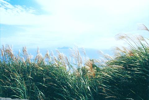
PHOTO: MIKE CLENDENIN, TAIPEI TIMES
We politely declined again, so he shrugged and went back to his work as we fell back in with the procession of hikers strolling alongside the fallow fields that hem in the lower part of this 19th century migratory route.
Farming has probably been one of the few things that hasn't changed in this area since people started walking the Tsaoling trail more than 200 years ago, heading for the fertile Lanyang Plain of present-day Ilan County.
Tuti Kung (Earth God) temples still abound along the route that Aborigines first used as part of a larger network that wound from Tamshui to Ilan, but they are now joined by amenities that earlier travelers could only have wished for: interpretive plaques, bathroom facilities, pavilions and sausage and ice cream vendors.
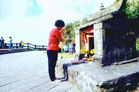
PHOTO: MIKE CLENDENIN, TAIPEI TIMES
In contrast to the hikers who do walk it for fun, during the early 1800s, mainland immigrants used it to avoid a more hazardous journey around the northeast coast from Tamshui. It was developed by the then Taiwan prefect Yang Yan-li, who adopted the aboriginal trail to make settling the Lanyang easier.
Preserved section
Only a tiny portion of this trail remains today, but it is well developed and ideal as a one-day getaway from Taipei. Winding up through a sparsely populated valley north of Fulung beach, the trail passes by rice paddies, patches of wild lilies and old, sometimes abandoned homes as it runs toward a break in the coastal foothills.
Most people begin the hike on the north end, heading south toward Tali and the Jade Emperor Temple. During the four-hour trip, hikers pass through three distinctive ranges, beginning in a low-lying farming plain, then crossing below forested ridges that eventually lead to a windy promontory from which uninhabited Turtle Island may be seen just a few kilometers off the northeast coast.
On the way up, the most bucolic section of the trail comes about one hour into the journey, starting from when the trail breaks left before a bridge and ascends a stone staircase that parallels a brook. Moss-dappled walls, flagstones scuffed smooth by the shuffle of millions of feet and tiny hollows on the brook where the crawfish nibble at your feet are all characteristics of this section.
Climbing out of the valley and toward the neck of the pass, the scenery abruptly changes. Leafy canopies and tree-lined paths give way to hillsides swept with silvergrass, their long, pliant necks bent by the sea-chilled gusts that race through the pass, sucked inland by the valley's warmer climate.
About 50 meters before the top is a large stone tablet with the character "Hu" -- tiger -- carved into it Placed there in 1867 by Taiwan Regional Commander Liu Ming-teng, it was intended as protection against fierce winds that rake the hilltops.
Crowded summit
On a Sunday afternoon, hundreds of people will pass over the flagstone terrace at the top of the pass, and the pavilion there will be chockablock with people craning for views up the coast. Despite chilly weather, the remote earth god shrine here does a brisk business, with pious visitors lining up before it, hands in prayer and clamped around sticks of incense. Just above the nearby pavilion, at the end of a short feeder trail, lies a quieter perch that's ideal for picnicking.
Although the main part of trail continues, dropping quickly into Tali, a lot of people just return via the valley. If you do choose to push onward, it's about a half-hour's walk to the temple of the Jade Emperor.
There are a few country roads that lead off the main trail as you head back, offering the promise of further exploration. You may see the odd farmer toiling away or a cow here or there, but for the most part these offshoots seem like lonely places that only the locals go to. The crowds thin by around 4 or 5pm making this a more pleasant time to slip into a quiet nook along the stream and enjoy the final few hours away from city life.
For your information:
Transportation By train: Stop at the Kungliao station near Fulung and walk for about 40 minutes to the Yuanwang-keng trailhead. From Tali station, walk about 10 minutes to the Jade Emperor Temple trailhead.
By car: Take the Sun Yat-sen freeway to the Keelung or Patu exit, then take Route 2 south along the coast. There's plenty of signage pointing the way to the trailhead. FYI: Although it's possible to drive all the way to the trailhead, many people park their cars near a bridge that's only a kilometer or so off the coastal highway. Also, taking a car out to the trail on the weekend only takes less than an hour, but the trip back may take up to two depending on traffic.
By bus: The Taipei to Lotung Chunghsing bus leaves approximately every 20 minutes. Get off in Fulung or Tali. Fulung to Keelung buses leave about once an hour.
Miscellaneous: It can be quite warm at the bottom of the trail and cool at the top, so pack a light jumper, especially if you plan on hanging out for awhile at the top. It's possible to buy snacks and tea along the way on weekends when travelling from north to south, but bring along some water anyway to keep hydrated through the steep parts.
ROLLER-COASTER RIDE: More than five earthquakes ranging from magnitude 4.4 to 5.5 on the Richter scale shook eastern Taiwan in rapid succession yesterday afternoon Back-to-back weather fronts are forecast to hit Taiwan this week, resulting in rain across the nation in the coming days, the Central Weather Administration said yesterday, as it also warned residents in mountainous regions to be wary of landslides and rockfalls. As the first front approached, sporadic rainfall began in central and northern parts of Taiwan yesterday, the agency said, adding that rain is forecast to intensify in those regions today, while brief showers would also affect other parts of the nation. A second weather system is forecast to arrive on Thursday, bringing additional rain to the whole nation until Sunday, it

CONDITIONAL: The PRC imposes secret requirements that the funding it provides cannot be spent in states with diplomatic relations with Taiwan, Emma Reilly said China has been bribing UN officials to obtain “special benefits” and to block funding from countries that have diplomatic ties with Taiwan, a former UN employee told the British House of Commons on Tuesday. At a House of Commons Foreign Affairs Committee hearing into “international relations within the multilateral system,” former Office of the UN High Commissioner for Human Rights (OHCHR) employee Emma Reilly said in a written statement that “Beijing paid bribes to the two successive Presidents of the [UN] General Assembly” during the two-year negotiation of the Sustainable Development Goals. Another way China exercises influence within the UN Secretariat is

LANDSLIDES POSSIBLE: The agency advised the public to avoid visiting mountainous regions due to more expected aftershocks and rainfall from a series of weather fronts A series of earthquakes over the past few days were likely aftershocks of the April 3 earthquake in Hualien County, with further aftershocks to be expected for up to a year, the Central Weather Administration (CWA) said yesterday. Based on the nation’s experience after the quake on Sept. 21, 1999, more aftershocks are possible over the next six months to a year, the agency said. A total of 103 earthquakes of magnitude 4 on the local magnitude scale or higher hit Hualien County from 5:08pm on Monday to 10:27am yesterday, with 27 of them exceeding magnitude 5. They included two, of magnitude

Taiwan’s first drag queen to compete on the internationally acclaimed RuPaul’s Drag Race, Nymphia Wind (妮妃雅), was on Friday crowned the “Next Drag Superstar.” Dressed in a sparkling banana dress, Nymphia Wind swept onto the stage for the final, and stole the show. “Taiwan this is for you,” she said right after show host RuPaul announced her as the winner. “To those who feel like they don’t belong, just remember to live fearlessly and to live their truth,” she said on stage. One of the frontrunners for the past 15 episodes, the 28-year-old breezed through to the final after weeks of showcasing her unique