The Taiwanese remote-sensing satellite FORMOSAT-2 has conducted a high-resolution photo surveillance of the collapsing Wilkins Ice Shelf in Antarctica, the most detailed observation ever of an ice shelf disintegration, reports said yesterday.
A large part of the Wilkins Ice Shelf began to break off on Feb. 28 and NASA has since issued a request for countries around the world to focus any available high-resolution satellites on the shelf, the FORMOSAT-2 operations center said.
The Wilkins Ice Shelf -- located 1,600km south of Cape Horn, the southernmost tip of South America -- covers a sea area of 16,000km2 near the Antarctic Peninsula. Since Feb. 28, an area of the shelf approximately twice the size of Taipei City has collapsed.
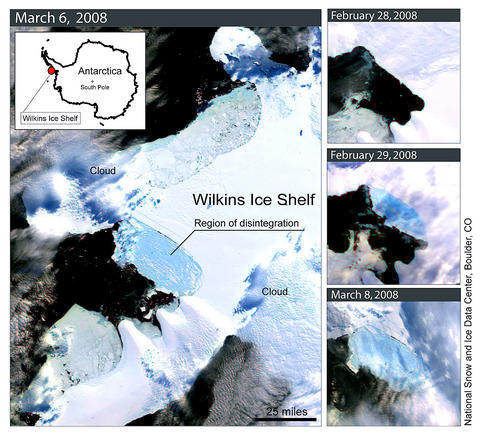
PHOTO: AFP
NASA made the request for assistance because the satellites already monitoring Antarctic ice shelves are all low resolution ones, such as the 1km resolution Terra satellite operated by the National Snow and Ice Data Center. Images taken at such a resolution do not reveal small-scale changes.
After being repositioned, FORMOSAT-2 -- the second of three weather satellites launched and operated by Taiwan -- commenced photo-surveillance on March 8, producing images with a 2m resolution covering areas of up to 24km, staff at the satellite's operations center said.
The staff are provided by National Cheng Kung University (NCKU) and the National Space Organization.
After analyzing the satellite images, geoscientists warned that the shelf is still in danger of large-scale disintegration, as the only buffer between the remaining shelf and rising sea temperatures is an ice belt of less than 6km wide. Large-scale disintegration of the shelf would raise the sea level, they said.
"This is the first time that such a high-resolution satellite has been deployed to monitor the Antarctic," said Liu Cheng-chie (劉正千), associate professor at NCKU's Department of Earth Sciences.
Liu, who assists in the operation of the satellite and established an automatic image processing system for it, said that most commercial satellites used for Antarctic observation were limited.
The detail of the satellite images taken by FORMOSAT-2 was such that the front of the shelf could be seen breaking into strips of ice several kilometers in length, but only hundreds of meters in width. As more of the shelf collapsed, so more sea water would be allowed to seep deeper into the structure, triggering further disintegration, he said.
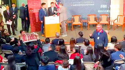
A group of Taiwanese-American and Tibetan-American students at Harvard University on Saturday disrupted Chinese Ambassador to the US Xie Feng’s (謝鋒) speech at the school, accusing him of being responsible for numerous human rights violations. Four students — two Taiwanese Americans and two from Tibet — held up banners inside a conference hall where Xie was delivering a speech at the opening ceremony of the Harvard Kennedy School China Conference 2024. In a video clip provided by the Coalition of Students Resisting the CCP (Chinese Communist Party), Taiwanese-American Cosette Wu (吳亭樺) and Tibetan-American Tsering Yangchen are seen holding banners that together read:

UNAWARE: Many people sit for long hours every day and eat unhealthy foods, putting them at greater risk of developing one of the ‘three highs,’ an expert said More than 30 percent of adults aged 40 or older who underwent a government-funded health exam were unaware they had at least one of the “three highs” — high blood pressure, high blood lipids or high blood sugar, the Health Promotion Administration (HPA) said yesterday. Among adults aged 40 or older who said they did not have any of the “three highs” before taking the health exam, more than 30 percent were found to have at least one of them, Adult Preventive Health Examination Service data from 2022 showed. People with long-term medical conditions such as hypertension or diabetes usually do not
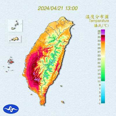
Heat advisories were in effect for nine administrative regions yesterday afternoon as warm southwesterly winds pushed temperatures above 38°C in parts of southern Taiwan, the Central Weather Administration (CWA) said. As of 3:30pm yesterday, Tainan’s Yujing District (玉井) had recorded the day’s highest temperature of 39.7°C, though the measurement will not be included in Taiwan’s official heat records since Yujing is an automatic rather than manually operated weather station, the CWA said. Highs recorded in other areas were 38.7°C in Kaohsiung’s Neimen District (內門), 38.2°C in Chiayi City and 38.1°C in Pingtung’s Sandimen Township (三地門), CWA data showed. The spell of scorching
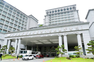
POLICE INVESTIGATING: A man said he quit his job as a nurse at Taipei Tzu Chi Hospital as he had been ‘disgusted’ by the behavior of his colleagues A man yesterday morning wrote online that he had witnessed nurses taking photographs and touching anesthetized patients inappropriately in Taipei Tzu Chi Hospital’s operating theaters. The man surnamed Huang (黃) wrote on the Professional Technology Temple bulletin board that during his six-month stint as a nurse at the hospital, he had seen nurses taking pictures of patients, including of their private parts, after they were anesthetized. Some nurses had also touched patients inappropriately and children were among those photographed, he said. Huang said this “disgusted” him “so much” that “he felt the need to reveal these unethical acts in the operating theater