More than a month after the 921 earthquake, the National Science Council (NSC) has completed a detailed map of the Chelungpu fault (
Highly anticipated by building contractors, the map of the Chelungpu fault, which has been drawn to a 1:5,000 ratio, was produced by 21 academics who have been conducting field investigations since the earthquake.
At the time of the quake, the most precise fault maps available were those of a 1:100,000 ratio, while the official one available from the Central Geological Survey (CGS) was of a 1:500,000 ratio.
"The NSC's newly produced Chelungpu fault map will be useful in considering rebuilding plans because construction prohibition zones and restricted zones can be identified by referring to it," Huang Chi-yue (
Huang said it would be easy to tell how far the fault is from damaged structures if CPA officials are making administrative maps of townships along the Chelungpu fault using the same scale as that of the NSC map.
"However, to better identify permanent prohibited zones and restricted zones along the fault, geologists have been given a tougher job -- producing a map of the same fault with a 1:1,000 ratio. This more detailed map should be completed by Dec. 15," he said.
NSC director Huang Chen-tai (
The 1:1,000 map, he added, would present the recorded geologic characters of the fault and would become an excellent reference to other thrust faults in western Taiwan.
Huang said scientists had discussed how to produce a detailed overall fault map, which would be more precise than any fault maps currently in use.
One of the challenges for contractors during rebuilding will be understanding exactly where the fault line lies. The ability to pinpoint the exact location of the fault has become a contentious point between construction engineers and scientists.
Taiwan is creased with a number of fault lines and geologists have said that it is impractical, if not impossible to map out all sections of every fault line on the island. Moreover, they say that increasing the detail of maps from 1:100,000 -- the ratio used by geologists for making scientific surveys -- to 1:1,000 in an invitation for error.
Builders argue that the more detailed maps are necessary for making blueprints that have the degree of accuracy that they are familiar with.
The builders say that maps currently available do not have nearly enough detail to allow them to know with certainty if they are building the specified distance away from an active fault line.
Scientists say the priority should be producing an official fault map using a 1:25,000 ratio, a standard which has been adopted by the US, Japan and other countries.
"It's not realistic to produce precise fault maps at 1:1,000. For geologists, the difficulty is knowing exactly where the faults are, especially those deep underground," said Shih Ruey-chyuan (石瑞銓), a seismologist from National Chung Cheng University.
"Instead of relying solely on fault maps, builders should make comprehensive site inspections before they break ground on any structure," said Tsai Yi-ben (蔡義本), professor and dean of the College of Earth Sciences at National Central University.
According to one British scientist who worked in Taiwan after the quake, fault maps are an essential guide for builders.
"If detailed maps are not available at construction sites, engineers will have to deal more with local conditions," said Colin Taylor, a civil engineering professor from Bristol University.
He said that the fault maps are needed either for scientists to identify the sources and mechanism of major earthquakes or for engineers to use during construction.
Although the UK is relatively small, its geology has been studied for more than 150 years.
"The governmental British Geological Survey has produced quite detailed geological maps of the UK in various scales. The most detailed one is 1:1,000," Taylor said.
Another engineer, Dave Edge from the UK-based WS Atkins Group, an engineering consulting firm, stressed the need for accurate maps: "One cannot be sure that the law [prohibiting the building of houses closer than 15 meters from a fault line] is successful unless one knows actually where the fault lines are."
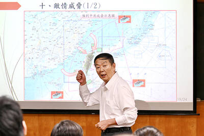
RETHINK? The defense ministry and Navy Command Headquarters could take over the indigenous submarine project and change its production timeline, a source said Admiral Huang Shu-kuang’s (黃曙光) resignation as head of the Indigenous Submarine Program and as a member of the National Security Council could affect the production of submarines, a source said yesterday. Huang in a statement last night said he had decided to resign due to national security concerns while expressing the hope that it would put a stop to political wrangling that only undermines the advancement of the nation’s defense capabilities. Taiwan People’s Party Legislator Vivian Huang (黃珊珊) yesterday said that the admiral, her older brother, felt it was time for him to step down and that he had completed what he

Taiwan has experienced its most significant improvement in the QS World University Rankings by Subject, data provided on Sunday by international higher education analyst Quacquarelli Symonds (QS) showed. Compared with last year’s edition of the rankings, which measure academic excellence and influence, Taiwanese universities made great improvements in the H Index metric, which evaluates research productivity and its impact, with a notable 30 percent increase overall, QS said. Taiwanese universities also made notable progress in the Citations per Paper metric, which measures the impact of research, achieving a 13 percent increase. Taiwanese universities gained 10 percent in Academic Reputation, but declined 18 percent
UNDER DISCUSSION: The combatant command would integrate fast attack boat and anti-ship missile groups to defend waters closest to the coastline, a source said The military could establish a new combatant command as early as 2026, which would be tasked with defending Taiwan’s territorial waters 24 nautical miles (44.4km) from the nation’s coastline, a source familiar with the matter said yesterday. The new command, which would fall under the Naval Command Headquarters, would be led by a vice admiral and integrate existing fast attack boat and anti-ship missile groups, along with the Naval Maritime Surveillance and Reconnaissance Command, said the source, who asked to remain anonymous. It could be launched by 2026, but details are being discussed and no final timetable has been announced, the source
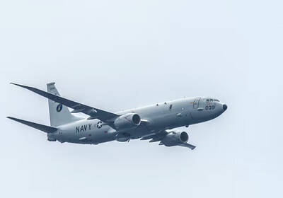
CHINA REACTS: The patrol and reconnaissance plane ‘transited the Taiwan Strait in international airspace,’ the 7th Fleet said, while Taipei said it saw nothing unusual The US 7th Fleet yesterday said that a US Navy P-8A Poseidon flew through the Taiwan Strait, a day after US and Chinese defense heads held their first talks since November 2022 in an effort to reduce regional tensions. The patrol and reconnaissance plane “transited the Taiwan Strait in international airspace,” the 7th Fleet said in a news release. “By operating within the Taiwan Strait in accordance with international law, the United States upholds the navigational rights and freedoms of all nations.” In a separate statement, the Ministry of National Defense said that it monitored nearby waters and airspace as the aircraft