Last week, I went to Jioujiou Peaks Nature Reserve (九 九峰自然保留區) in Nantou County’s Caotun Township (草屯鎮). At least, I think I did. I can’t be sure, because I haven’t been able to find a sufficiently detailed map of the reserve, and during the morning I spent in the area, I didn’t see any unambigious boundary markers.
Not knowing precisely where the reserve begins wouldn’t matter so much, but for the warning I saw on a bilingual signboard. Those who enter without authorization may be fined between NT$30,000 and NT$150,000, while those who “damage or alter natural conditions” or collect specimens face an additional fine of NT$200,000 to NT$1 million.
So even if I was positive I’d been inside, I’d be wise not to admit to the fact in a newspaper article. Or perhaps it wouldn’t matter in the slightest. I’ve browsed several Chinese-language blog posts about this corner of Nantou, and none mentions getting a permit.
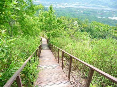
Photo: Steven Crook
I approached the area from the southwest by bicycle. Avoiding the busier roads in the center of Caotun, I joined Highway 14 where it points directly at the distinctively steep hills of Jioujiou Peaks. The Chinese toponym implies there are 99 peaks; there are certainly more pinnacles than I could count.
Highway 14 crosses the Wu River (烏溪), runs parallel with Freeway 6 for just under 2km on its northbank, then crosses back over to the southbank. Just east of Shuangdong Police Station (雙冬派出所), I found the turnoff to Shihjhuo Bridge (石灼橋). Crossing the river once again, I followed the signs for the Caotun Bike Trail Jioujiou Peaks Branch (草屯自行車道九九峰支線) and made my way north up a rough, steep and narrow road called Jhongsin Lane (中心巷).
There was a dry-as-dust creekbed to my left. To my right, some of the land was used to grow fruit. I stopped to examine a pile of sawdust-like matter dumped beside the road. When I spotted a few mushrooms mixed in with it, I realized that it was spent substrate from a mushroom farm, a concoction that usually includes rice bran, and which some farmers use to improve soil texture.
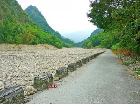
Photo: Steven Crook
Some 1.6km beyond Shihjhuo Bridge, I came to the signboard and another bridge. By crossing the bridge, was I entering the nature reserve? A sign said the biking route ended here, but there was no gate or barrier. I kept going on a concrete track that stayed very close to the creek, slowing often to avoid small rocks, distracted by the sheer number and variety of butterflies.
I felt immersed in nature. I couldn’t see another soul, and I couldn’t hear a single motor vehicle. But the garbage made me think I hadn’t yet reached the nature reserve — or, if I had, that it isn’t well maintained or policed. Later, when I was leaving, I took with me more than a dozen plastic bottles, plus several coffee cans.
After another 1.7km, the road began to climb away from the creek. I parked my bike and proceeded on foot. In darker corners of the forest, I found a variety of ferns and several fine specimens of Elephant Ear. According to a Forestry Bureau Web page, the canopy here includes longan and lychee trees, Trema orientalis (a relative of the hemp sometimes called the Indian charcoal-tree), Taiwan copperleaf (Acalypha angatensis) and bamboo.
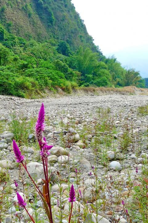
Photo: Steven Crook
AFTER DARK
If you were to explore the reserve at night, you might spot a Taiwan ferret badger (Melogale moschata subaurantiaca). Some years back, researchers were surprised to find here the goat-like Taiwan Serow (Capricornis swinhoei), which usually lives at higher altitudes and further from humanity. I didn’t see any Formosan rock macaques (Macaca cyclopis), but I heard them crashing through the canopy, and I saw their feces on the road.
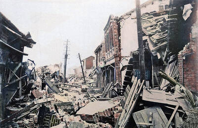
I hiked as far as I could, which was less than a kilometer. Freewheeling back toward civilization, I stopped again at the signboard to see what else I could glean from it. In some respects, it’s very informative. The 921 Earthquake, which ravaged central Taiwan just over 20 years ago, shook loose layers of compacted gravel. When they slid, they dislodged topsoil and foliage. Overnight (the quake struck at 1:47am) the once-verdant Jioujiou Peaks became mostly bald.
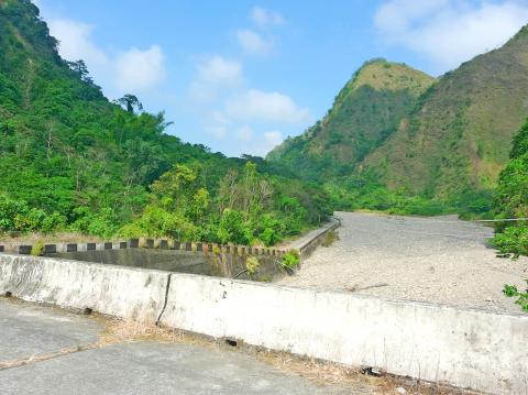
Photo: Steven Crook
Recognizing the distinctiveness of the landscape, and realizing that the environment wouldn’t recover unless it were protected, less than a year after the disaster the Council of Agriculture created this reserve. The highest point is 780m above sea level, the lowest is at 200m, and the entire reserve covers 1,198 hectares.
The authorities also created an official hiking trail, which I visited before the summer. This 1.93-km-long path begins near Pinglin Elementary School (平林國小), around 3km to the west of Shihjhuo Bridge as the crow flies; look for signs reading “99 Peaks Forest Trail” (九 九峰森林步道).
The 99 Peaks Forest Trail climbs from 280m above sea level to an elevation of 485m. I spent about two hours doing a full circuit, which gave me plenty of time to enjoy views toward the nature reserve and also over central Caotun. There’s a good amount of shade along the way, and enough steps to give your legs a proper work-out.
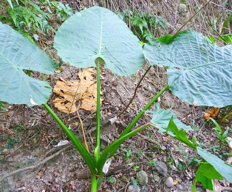
Photo: Steven Crook
Located between the trailhead and Highway 14, Yu-Hsiu Museum of Art (毓繡美術館) is sometimes worth a look. Even if the art isn’t your thing, you’ll appreciate the air-conditioning and clean bathrooms. For details of current and upcoming exhibitions, visit www.yu-hsiu.org.
Steven Crook has been writing about travel, culture, and business in Taiwan since 1996. He is the co-author of A Culinary History of Taipei: Beyond Pork and Ponlai, and author of Taiwan: The Bradt Travel Guide, the third edition of which has just been published.
The year was 1991. A Toyota Land Cruiser set out on a 67km journey up the Junda Forest Road (郡大林道) toward an old loggers’ camp, at which point the hikers inside would get out and begin their ascent of Jade Mountain (玉山). Little did they know, they would be the last group of hikers to ever enjoy this shortcut into the mountains. An approaching typhoon soon wiped out the road behind them, trapping the vehicle on the mountain and forever changing the approach to Jade Mountain. THE CONTEMPORARY ROUTE Nowadays, the approach to Jade Mountain from the north side takes an

Last week Joseph Nye, the well-known China scholar, wrote on the Australian Strategic Policy Institute’s website about how war over Taiwan might be averted. He noted that years ago he was on a team that met with then-president Chen Shui-bian (陳水扁), “whose previous ‘unofficial’ visit to the US had caused a crisis in which China fired missiles into the sea and the US deployed carriers off the coast of Taiwan.” Yes, that’s right, mighty Chen caused that crisis all by himself. Neither the US nor the People’s Republic of China (PRC) exercised any agency. Nye then nostalgically invoked the comical specter

Relations between Taiwan and the Czech Republic have flourished in recent years. However, not everyone is pleased about the growing friendship between the two countries. Last month, an incident involving a Chinese diplomat tailing the car of vice president-elect Hsiao Bi-khim (蕭美琴) in Prague, drew public attention to the People’s Republic of China’s (PRC) operations to undermine Taiwan overseas. The trip was not Hsiao’s first visit to the Central European country. It was meant to be low-key, a chance to meet with local academics and politicians, until her police escort noticed a car was tailing her through the Czech capital. The
April 15 to April 21 Yang Kui (楊逵) was horrified as he drove past trucks, oxcarts and trolleys loaded with coffins on his way to Tuntzechiao (屯子腳), which he heard had been completely destroyed. The friend he came to check on was safe, but most residents were suffering in the town hit the hardest by the 7.1-magnitude Hsinchu-Taichung Earthquake on April 21, 1935. It remains the deadliest in Taiwan’s recorded history, claiming around 3,300 lives and injuring nearly 12,000. The disaster completely flattened roughly 18,000 houses and damaged countless more. The social activist and