There’s a curious consensus among many lovers of the Matsu islands that Dongyin (東引) is the most beautiful. With it’s easternmost peninsula, the famous Lienyu Yikeng Cliff (烈女義坑, also known as Suicide Cliff), stunningly situated lighthouse and extraordinary Yisiantian (一線天, also known as Thread of Sky), Dongyin has a lot on offer. Yet the island also has the heaviest remaining military presence of any in the Matsu group. Until nature is allowed to take over and soften many a cruel blemish and scar, visitors will have to ignore many eyesores en route to Dongyin’s scenic highlights.
On the frontline
Dongyin is connected with the neighboring island of Xiyin (西引) by a causeway, and while this sister islet is less visited, it has several natural and militaristic sights of great interest. Incidentally, the heavy military presence on both islands means it’s best to keep your ID on you while exploring — on my last visit it was still needed to visit a couple of the sights — and be careful where you point your camera.
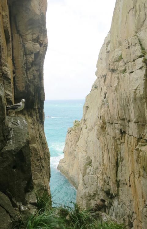
Photo: Richard Saunders
Ferries from Taiwan and Nangan Island (南竿島) all dock at Jhongjhu Harbor (中柱港), at the southern edge of Jhongliou (中柳村) and Lehua (樂華村) villages, which mingle to form the main settlement on the island.
Heading south from the harbor, the coast road climbs high above the ocean to turn west at Dongyin Visitor Center (東引旅客中心), where a side road descends to the seashore and Beihai Tunnel (北海隧道), dug between 1968 and 1970. At 148 meters, it’s the smallest of the three subterranean harbors in the Matsu islands. The others are on Nangan and Beigan (北竿) islands, but, like those, this one was dug by hand with the aid only of dynamite. Unfortunately it’s been “temporarily” closed for many years now, since the roof of the tunnel is apparently unstable.
Caves and tunnels
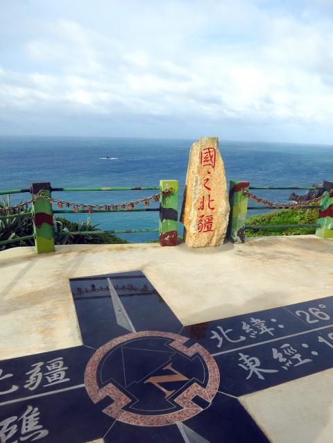
Photo: Richard Saunders
After the visitor center, take the next (signposted) turn on the right, and follow the signs to the trailhead for the short walk out to “Yanxiao Echoing with Tidal Cave” (燕秀潮音). This notable example of Chinglish describes a huge cavern whose roof has fallen in, exposing a deep, narrow crater, linked to the ocean by a long cleft, through which the sea pounds with an impressive roar. The cliffs on the crater side are densely covered in foliage so it’s hard to see into the void, but even half-glimpsed it’s an impressive place.
The main road now heads inland back toward Lehua village and Dongyin Distillery (東引酒廠), founded in 1961 and one of two distilleries in Matsu that produce Kaoliang spirit.
A kilometer or so further east, along a succession of signposted roads, lies Andong Tunnel (安東坑道), Dongyin’s most impressive military relic (excavated in the 1970s), and an unmissable attraction. The entrance to the complex is via a long, descending and seemingly endless tunnel which presents an interesting optical illusion, as it’s far longer than at first appears as you walk down. At the bottom, tunnels branch off in different directions, several ending suddenly at dramatic viewpoints in vertical sea cliffs. The gun turrets at Andong Tunnel are favorite bird watching spots, and the sight of large flocks of seagulls and terns circling in the deep sea-worn chasms is one of Matsu’s most memorable experiences.
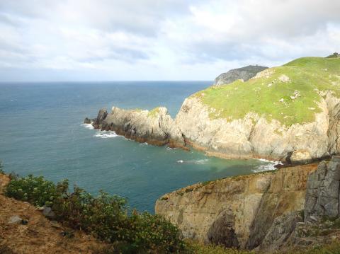
Photo: Richard Saunders
The western half of Dongyin has some impressive sights, but it’s the easternmost peninsula of the island (just a short zip by hire scooter from Jhongliu village) where the most breathtaking coastal scenery is found. First, below a small military compound, is the incredible cleft, Thread of Sky. A soldier may or may not walk up with pen and paper as you draw up at the parking area. Sign in with your ID if he does, and follow the steps down the grassy hillside and into the crevice. Thread of Sky isn’t especially big, but it’s extremely narrow, as the name suggests, and the short walk down there is stunning.
Killer views
Another couple of hundred meters east, steps lead down from the road to the utterly spectacular Suicide Cliff, rightly Dongyin’s most famous sight. It’s just a few meters from the road to the end of the natural, diving board-like tongue of land that extends into this fearsome ocean-eroded chasm, but the view down the sheer cliffs to the rocks far below is guaranteed to give vertigo sufferers a severe case of the willies.
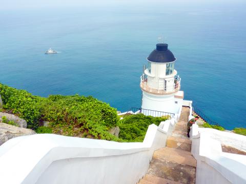
Photo: Richard Saunders
Historic monument
At the easternmost tip of the island a path follows the cliffs to the historic, British-designed Dongyin Lighthouse (東引燈塔), a Grade Three Historic Monument completed in 1904.
The lighthouse stands in a wild and magnificent spot, halfway up a craggy cliff, and the views over the cliffs and the ocean far below are inspirational on a good day. A side trail on the right on the way to the lighthouse leads down the cliffs to a pair of fog cannons, used in the past when poor visibility meant the lighthouse was ineffective.
The independent island of Xiyin is joined to the bigger Dongyin by the 500 meter-long Jhongjhu causeway (completed in 1986). Once across the causeway, follow the road uphill onto Xiyin’s steep slopes and several fine natural and military attractions. Most unmissable is the clifftop viewing platform called the Guojhih Beijiang (國之北疆), or Northernmost Frontier.
This point (or rather the Beigu Reef (北固礁) just offshore) constitutes the northernmost territory of the Matsu archipelago, and is certainly a fittingly majestic spot. The view, incorporating the rock pinnacles of the Luohanping (羅漢坪), or Eighteen Luohan, is as wild and exhilarating as any to be found in Taiwan.
Richard Saunders is a classical pianist and writer who has lived in Taiwan since 1993. He’s the founder of a local hiking group, Taipei Hikers, and is the author of six books about Taiwan, including Taiwan 101 and Taipei Escapes. Visit his Web site at www.taiwanoffthebeatentrack.com.

Last week Joseph Nye, the well-known China scholar, wrote on the Australian Strategic Policy Institute’s website about how war over Taiwan might be averted. He noted that years ago he was on a team that met with then-president Chen Shui-bian (陳水扁), “whose previous ‘unofficial’ visit to the US had caused a crisis in which China fired missiles into the sea and the US deployed carriers off the coast of Taiwan.” Yes, that’s right, mighty Chen caused that crisis all by himself. Neither the US nor the People’s Republic of China (PRC) exercised any agency. Nye then nostalgically invoked the comical specter
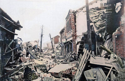
April 15 to April 21 Yang Kui (楊逵) was horrified as he drove past trucks, oxcarts and trolleys loaded with coffins on his way to Tuntzechiao (屯子腳), which he heard had been completely destroyed. The friend he came to check on was safe, but most residents were suffering in the town hit the hardest by the 7.1-magnitude Hsinchu-Taichung Earthquake on April 21, 1935. It remains the deadliest in Taiwan’s recorded history, claiming around 3,300 lives and injuring nearly 12,000. The disaster completely flattened roughly 18,000 houses and damaged countless more. The social activist and

Over the course of former President Ma Ying-jeou’s (馬英九) 11-day trip to China that included a meeting with Chinese Communist Party (CCP) leader Xi Jinping (習近平) a surprising number of people commented that the former president was now “irrelevant.” Upon reflection, it became apparent that these comments were coming from pro-Taiwan, pan-green supporters and they were expressing what they hoped was the case, rather than the reality. Ma’s ideology is so pro-China (read: deep blue) and controversial that many in his own Chinese Nationalist Party (KMT) hope he retires quickly, or at least refrains from speaking on some subjects. Regardless

Approaching her mid-30s, Xiong Yidan reckons that most of her friends are on to their second or even third babies. But Xiong has more than a dozen. There is Lucky, the street dog from Bangkok who jumped into a taxi with her and never left. There is Sophie and Ben, sibling geese, who honk from morning to night. Boop and Pan, both goats, are romantically involved. Dumpling the hedgehog enjoys a belly rub from time to time. The list goes on. Xiong nurtures her brood from her 8,000 square meter farm in Chiang Dao, a mountainous district in northern Thailand’s