The first time I gazed on the storied coast of Alaska I was standing lens-to-lens with dozens of my fellow passengers on the deck of a cruise ship. To say we were bowled over would be a serious understatement. Mountain after mountain, each streaked with a different pattern of snow, exploded from a silver-gray sea into a gray-silver sky - and it all seemed to go on forever. The engines churned, the ship sailed on and the spectacular beauty kept rolling by.
But after a while, I wanted more than scenery. I wanted, well, Alaska: Wildlife sightings without a score of whirring shutters. Hikes without a sign-up sheet. Random, unscripted encounters with people and places. Silence. Solitude.
I wanted to see some of Alaska's 54,563km of coast without having to strain against a ship's safety rail. I wanted to get out on the road and drive, to see the beauty of the Last Frontier up close and at my own pace.
PHOTOS: NY TIMES NEWS SERVICE
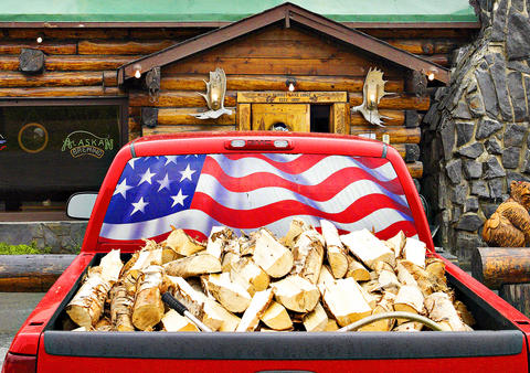
Though most visitors see Alaska from the deck of a cruise ship, the reality is that this state, despite its lack of highways and abundance of challenging terrain, can be the setting for a perfect road trip - one that takes the driver through canyons carved by jade-green rivers, along deserted beaches teeming with shellfish and shorebirds and past century-old miners' cabins and dark bars serving up cool mugs of amber brews.
So, earlier this summer, my wife, Kate, and I set out on a six-day journey in a rented Chevy Cobalt, on a route that formed a rough arc through the Kenai Peninsula south of Anchorage. Just 20 minutes after leaving the Anchorage airport, heading south on Seward Highway, we got our first payoff at Turnagain Arm, the dark, tapered fjord that separates the Chugach Range from the mountains and lakes of the Kenai (pronounced KEY-nigh).
I'd never seen mountains so big rising so close to salt water; I'd never seen so many peaks so close to a city; I'd never felt so dwarfed by highway scenery. Twenty-four kilometers into the trip, I'd already exhausted my supply of superlatives.
The plan for that afternoon was to head toward a little town called Hope, a 29km detour off the Seward Highway on the far side of Turnagain Arm, and stop on the way there for a whitewater raft trip down Sixmile Creek. Kate was game, but my resolve got a little wobbly when the temperature refused to budge from 10°C - and it collapsed altogether once we scrambled down a rough path to the river bank and I got a look at the rapids slamming against the canyon walls.
"You know they lose three or four every year from those rafts," Jim Tudor told me later as we stood by the stove in the Hope-Sunrise Historical Society and Mining Museum, where he is a docent, and talked about the gold rush days that got the town going in the 1890s. Who needs class V rapids when you can while away an afternoon peering at old photos, stuffed owls and gold nuggets?
Downtown Hope - a bar, a store, magpies singing from big clumps of Alaska elderberry and a collection of quaint log cabins set back from an immense tidal flat on Turnagain Arm - was pretty much deserted. But someone must love the place dearly because these cabins have withstood more than a century of Alaska weather in pristine condition.
Not counting spurs and side roads, there are only two highways that serve the Kenai: the Seward Highway, which runs more or less north-south for 203km between Anchorage and Seward, and the Sterling Highway, which cuts west off the Seward Highway 145km south of Anchorage then turns south along the peninsula's west coast to Homer, covering 254km.
Cooper Landing, 18km west of the junction of the Sterling and Seward Highways in the middle of the peninsula, seemed like a good place to stop for the first night. Anyway, I liked the sound of the name.
bear necessities
Aside from its stunning location where the long snaking Kenai Lake flows into the milky green Kenai River, the town isn't much to look at. A series of cabins equipped with fish freezers and billboards boasting of fishing and rafting trips, Cooper Landing is all about bagging big salmon - and since the fish hadn't appeared yet, there wasn't much going on. What to do on a gray, drizzly morning?
"Drive out to Skilak Lake Road," suggested a woman who worked at the Kenai Princess Wilderness Lodge, where we spent the night, describing how to pick up the rutted dirt road that cuts through a corner of the Kenai National Wildlife Refuge west of town. "This is where the locals take their guests to see bears."
No bears were spotted in the course of the drive, though there was a striking change in scenery. No sooner had the billboards of Cooper Landing disappeared than the jagged peaks that had encircled us since Anchorage relaxed into smooth ridges and rounded humps rising from wide glassy waters. Trail signs beckoned every few kilometers, and so, despite the dreary weather and elevated threat level for bears, we decided to take a hike.
A helpful sign at the start of the 4km Skilak Lookout Trail explained in graphic detail how to "resolve" all manner of ursine encounters. Singing loudly to alert lurking bears to the presence of a couple of out-of-tune idiots, we set off into the dripping underbrush.
By the end of the hike we became rather lax about bear patrol and even regretted that we'd encountered no wildlife more thrilling than the celestial-voiced Swainson's thrush and some seagulls, which fly inland to feed on young salmon in the gravelly shallows of Hidden Creek.
Back in the car, though, luck was with us. A kilometer or two down the road, two black shapes - from a distance they looked like very fat round Labrador retrievers - resolved themselves into adolescent bears. They paused to scope out our car and then beat it back into the underbrush.
Luck, as it turned out, really was with us. A week later, a bear mauled a family's dog right in this area and then turned on the dog's owner, who shot the bear with a .44 Magnum. According to John Morton, supervisory biologist at the Kenai National Wildlife Refuge, about 25 bears are killed each year on the Kenai Peninsula by people protecting life or property.
The next morning, with the view shrouded in low clouds, we drove a half-kilometer south to Seward's other hub - an older, slightly less touristy downtown of gift shops, bars, restaurants and hotels. We stopped for coffee at an old church that has been born again as the Resurrect Art Coffee House Gallery. Amid the bulletin board postings for American tribal-style belly dancing, carrot cake and shawls, I stumbled on a volume entitled Wilderness by the artist Rockwell Kent about a 1918 sojourn with his 9-year-old son on Fox Island across the bay.
bracing weather
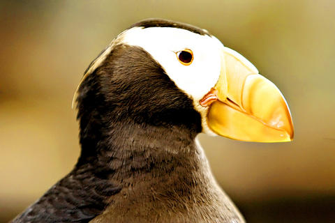
The next morning, it was raining, so instead of a hike we opted for the Alaska SeaLife Center. I had read that this marine-animal research and rehabilitation facility was partly financed by the settlement of the Exxon Valdez oil spill, so I came braced for a long, pious immersion in marine ecology. But I was practically elbowing tots out of the way to get a better view of puffins and guillemots torpedoing to the bottom of a bird habitat dive tank. Who knew that seabirds flew underwater?
As we drove out of town, Kate wondered why I hadn't allotted more time for the wonders of Seward.
Our next stop was Homer, the end of the road in the southwest corner of the Kenai Peninsula. But first we made a wet backtrack through Cooper Landing and then a long trek south through a series of cheerless lowland outposts hawking antler carvings, knives, "show girls" and soft ice cream. The first picturesque thing we came to was the old Transfiguration of Our Lord Russian Orthodox Church on a rise above the village of Ninilchik - white clapboard, green trim, gold-painted onion domes and heart-stopping views to the volcanoes across Cook Inlet.
Homer, 64km farther south, has something of the same stark beauty, but the sharp, clean maritime atmosphere has a funky espresso overlay. The town has artists and galleries galore, terrific restaurants, stupendous views of wide water and high mountains, but it's not exactly postcard pretty. The 7km spit that pokes into Kachemak Bay swarms with fish joints, halibut charters, rowdy bars and souvenir shops, but it's too rough and too weird to be a tourist trap.
Too hilly for easy biking, often too windy to kayak and with annoying traffic downtown, Homer nonetheless casts a powerful spell. It's like a stripped down, maritime, far-north cousin to Santa Fe.
If you go down to the woods today ...
Since the day was dry with patches of blue sky we decided to grab a water taxi and head across the bay to Kachemak Bay State Park - 161,874 hectares of mountains, glaciers, pebble beaches, trails and lagoons. The plan was to hike from the Glacier Spit Trailhead to the Grewingk Glacier Lake, admire the glacier, and return via the Saddle Trail, making a nearly 8km loop ending at Halibut Cove. The water taxi driver promised to collect us four hours later.
We were five minutes into the woods when thrashing in the brush froze us in our tracks; a moose glared through the tree trunks, shambled a few meters, glared again. Ten minutes later, the same thing - only this time it was a bear. I summoned what I could remember of the advice on that sign near Skilak Lake: look big, back away slowly, don't run.
The bear, black and smallish but still formidable, did not charge but neither did it flee. At some point, we regained the equanimity to turn our backs and continue the hike, which passed uneventfully - if you can call four hours in the company of bald eagles, wildflowers, flickering cottonwoods and a lake flowing from the mouth of a glacier and floating an armada of crystalline icebergs uneventful.
When the water taxi arrived, there was another passenger on board, a youngish, somewhat nervous Englishman who was planning to camp and kayak alone in the park. Part of me was envious - we were heading home while he was looking forward to days by himself in all of this.
"We saw a moose not a hundred yards off the beach," I told the fellow as he hauled his gear off the boat. "And a bear just beyond. Pretty bold."
It pleased me no end to see his eyes widen and a muscle work in his jaw.
"You know, many more people get hurt and killed by moose than by bears," the water taxi driver remarked as we were zipping back across the bay. "They get mad and stomp and kick you. Of course, if there are two of you and you split up, a moose just gets confused and leaves you both alone. They're that dumb."
Something to ponder over a farewell beer on the Homer Spit.
In late October of 1873 the government of Japan decided against sending a military expedition to Korea to force that nation to open trade relations. Across the government supporters of the expedition resigned immediately. The spectacle of revolt by disaffected samurai began to loom over Japanese politics. In January of 1874 disaffected samurai attacked a senior minister in Tokyo. A month later, a group of pro-Korea expedition and anti-foreign elements from Saga prefecture in Kyushu revolted, driven in part by high food prices stemming from poor harvests. Their leader, according to Edward Drea’s classic Japan’s Imperial Army, was a samurai
Located down a sideroad in old Wanhua District (萬華區), Waley Art (水谷藝術) has an established reputation for curating some of the more provocative indie art exhibitions in Taipei. And this month is no exception. Beyond the innocuous facade of a shophouse, the full three stories of the gallery space (including the basement) have been taken over by photographs, installation videos and abstract images courtesy of two creatives who hail from the opposite ends of the earth, Taiwan’s Hsu Yi-ting (許懿婷) and Germany’s Benjamin Janzen. “In 2019, I had an art residency in Europe,” Hsu says. “I met Benjamin in the lobby
April 22 to April 28 The true identity of the mastermind behind the Demon Gang (魔鬼黨) was undoubtedly on the minds of countless schoolchildren in late 1958. In the days leading up to the big reveal, more than 10,000 guesses were sent to Ta Hwa Publishing Co (大華文化社) for a chance to win prizes. The smash success of the comic series Great Battle Against the Demon Gang (大戰魔鬼黨) came as a surprise to author Yeh Hung-chia (葉宏甲), who had long given up on his dream after being jailed for 10 months in 1947 over political cartoons. Protagonist

Peter Brighton was amazed when he found the giant jackfruit. He had been watching it grow on his farm in far north Queensland, and when it came time to pick it from the tree, it was so heavy it needed two people to do the job. “I was surprised when we cut it off and felt how heavy it was,” he says. “I grabbed it and my wife cut it — couldn’t do it by myself, it took two of us.” Weighing in at 45 kilograms, it is the heaviest jackfruit that Brighton has ever grown on his tropical fruit farm, located